
Makalu Base Camp Trek Altitude
12 Feb 2026
When trekkers think of remote Himalayan adventures, few routes compare to the Makalu Base Camp trek altitude challenge. Nestled in the shadow of the w...
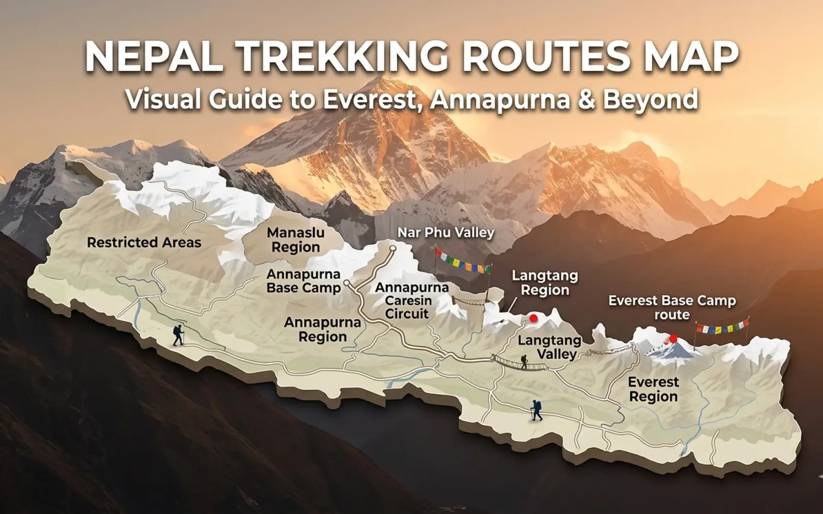

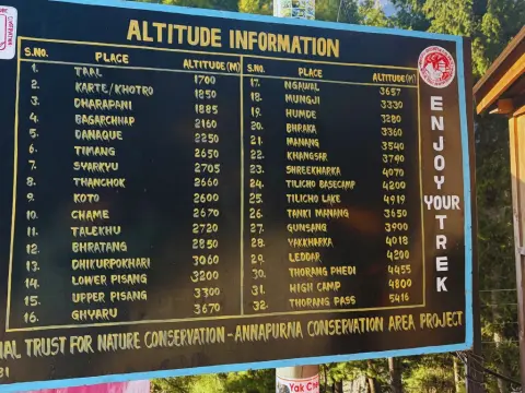
Nepal is the world's most extraordinary trekking destination — and having a reliable Nepal trekking routes map is the single most important planning tool you'll use before you ever set foot on a trail. Whether you're aiming for the shadow of Everest, circling the Annapurna massif, or venturing into the restricted wilderness of Nar Phu, each route demands its own understanding of the terrain, altitude, and logistics. This guide gives you exactly that: a clear, region-by-region visual breakdown of every major Himalayan trail, with start points, key villages, altitude comparisons, and honest advice on who each trek is best suited for.
We've walked all of these trails — multiple times, in multiple seasons. This isn't a Google Maps exercise. It's the kind of route knowledge our guides carry in their heads, now laid out for you on the page.
Nepal divides naturally into five trekking regions, each with its own character, culture, altitude range, and permit requirements. Think of this as the macro-level Nepal trekking map — the big picture before you zoom into individual trails.
Below is the core of this guide: a route-by-route breakdown of Nepal's most significant trekking trails. Each section functions as its own mini trekking map, covering the full route flow, critical altitude points, duration, and what makes the trail worth walking.
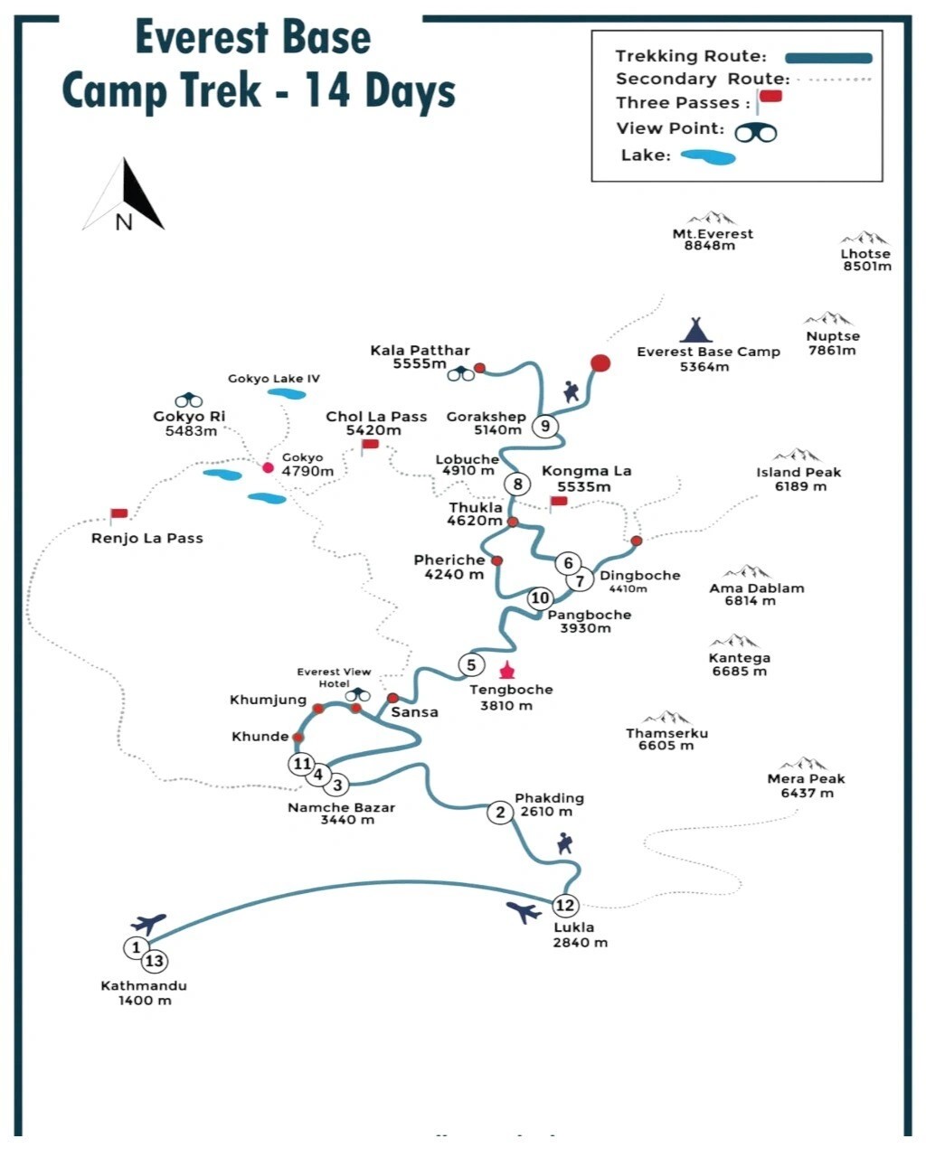
Khumbu Region · The world's most iconic trekking trail
Route: Lukla (2,860m) → Namche Bazaar (3,440m) → Dingboche (4,410m) → Lobuche (4,940m) → Everest Base Camp (5,364m)
Max Altitude: 5,364m Duration: 12–14 days Distance: ~130km Difficulty: Moderate+
The Everest Base Camp trek is, without question, the most recognisable high-altitude walk on earth. The trail begins with a white-knuckle flight into Lukla's famously short runway, then climbs steadily through rhododendron forest before reaching the bustling Sherpa capital of Namche Bazaar — the place where most trekkers first feel altitude's grip.
Above Namche, the landscape shifts into something lunar and extraordinary. The Khumbu Glacier grinds beside you as you approach base camp, and if the clouds clear at Kala Patthar (5,645m), you'll see Everest's summit pyramid in a way the base camp itself doesn't quite offer.
Fit trekkers with no high-altitude experience who want a structured, teahouse-supported route with cultural depth. Not technically demanding — but altitude acclimatisation is non-negotiable. Spend at least two nights in Namche and one in Dingboche before pushing higher.
Watching dawn light catch Ama Dablam from the Tengboche ridge — one of those views that permanently recalibrates your understanding of what mountains can look like.
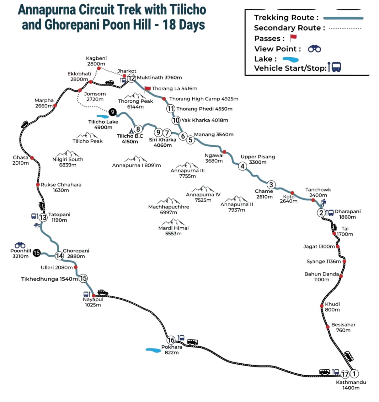
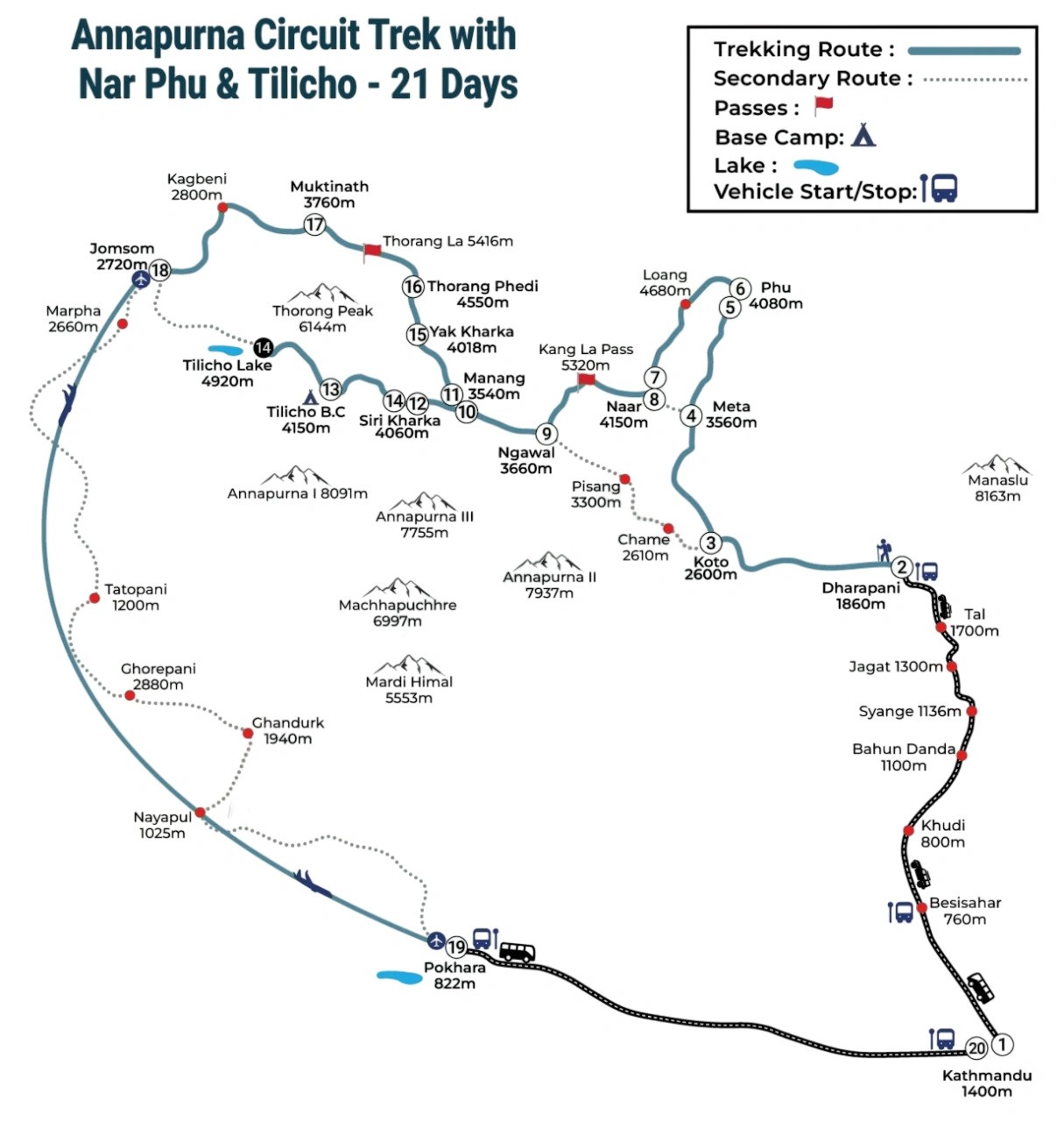
Annapurna Region · Nepal's greatest trekking loop
Route: jagat (1300m) → Manang (3,519m) → Thorong La Pass (5,416m) → Muktinath (3,800m) → Tatopani (1,190m)
Max Altitude: 5,416m Duration: 14–21 days Distance: 160–230km Difficulty: Moderate
For sheer diversity, nothing in Nepal matches the Annapurna Circuit. In a single trek you'll walk through subtropical river valleys, Gurung villages draped in marigolds, high-altitude semi-desert, and finally down into the Kali Gandaki gorge — the deepest gorge on earth.
The Thorong La pass is the circuit's centrepiece: a 5,416m crossing that most trekkers tackle in an early-morning push from High Camp. Cross it, and the world literally changes — from the green, wetter east to the dry, Tibetan-flavoured west where Muktinath's Hindu and Buddhist temples mark one of Nepal's most sacred pilgrimage sites.
Trekkers who want dramatic landscape variety, cultural immersion, and a genuine sense of journey. The road construction along parts of the lower circuit has changed the experience, so start from Chame or Dharapani if you want to skip the dusty jeep-track sections.
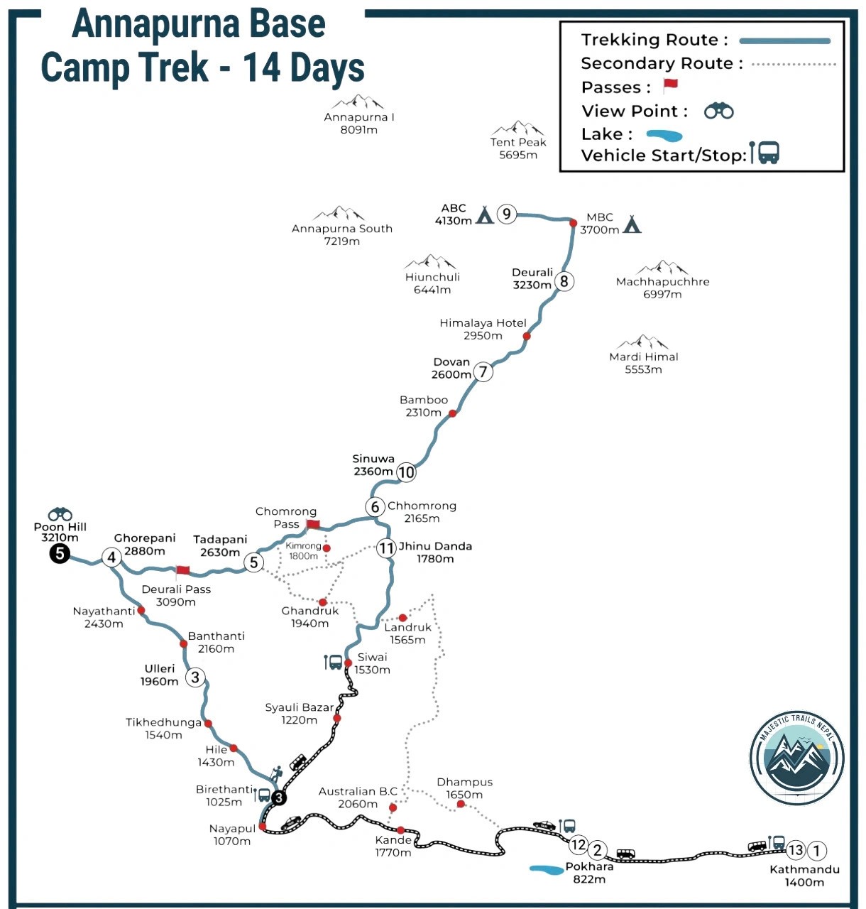
Annapurna Region · The amphitheatre experience
Route: Nayapul (1,070m) → Chhomrong (2,170m) → Himalaya Hotel (2,920m) → Machhapuchhre Base Camp (3,700m) → Annapurna Base Camp (4,130m)
Max Altitude: 4,130m Duration: 7–12 days Distance: ~110km Difficulty: Moderate
The ABC route is Nepal's finest short trek. The Modi Khola gorge narrows dramatically as you climb, rhododendron forests giving way to snow-dusted moraines before opening into the Annapurna Sanctuary — a glacial bowl completely ringed by peaks above 7,000m. It feels like walking into the centre of a mountain crown.
Unlike EBC, you stand at base camp inside the mountain system, not at its foot. The sunrise alpenglow on Annapurna South from the sanctuary is something our guides still photograph on their personal phones, even after dozens of trips.
First-time Himalayan trekkers, couples, and shorter itineraries. Lower altitude makes acclimatisation more manageable, but the scenery is absolutely on par with routes twice the length.
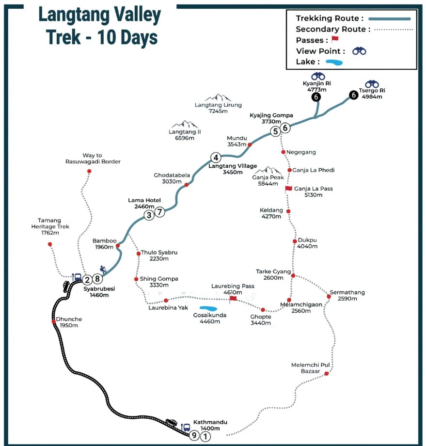
Langtang Region · Nepal's closest wilderness from Kathmandu
Route: Syabrubesi (1,550m) → Lama Hotel (2,470m) → Langtang Village (3,430m) → Kyanjin Gompa (3,870m)
Max Altitude: 3,870m (optional high point 5,000m+) Duration: 7–10 days Distance: ~65km Difficulty: Moderate
The 2015 earthquake reshaped Langtang in the most devastating way imaginable — but the region has rebuilt, and trekking here now carries the additional weight of supporting a community that lost nearly everything. Kyanjin Gompa at the valley's head is a working Buddhist monastery with a small cheese factory, and the viewpoint hike above it to Kyanjin Ri (4,773m) offers panoramas that rival anything on the more famous routes.
Trekkers with limited time, those wanting fewer crowds, and anyone who values cultural encounters over summit bragging rights. The Tamang people of Langtang are among the most welcoming hosts in the Himalayas.
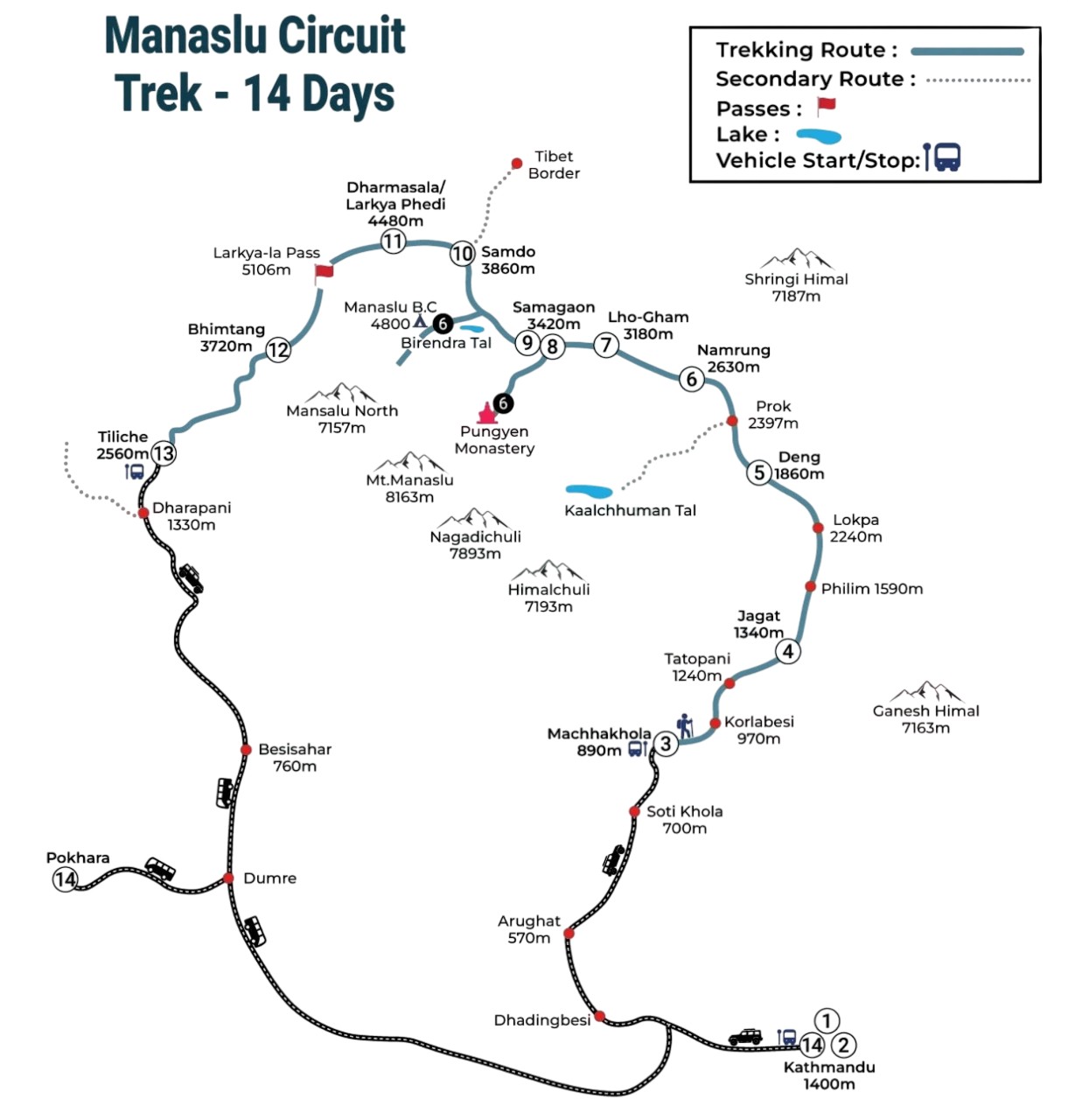
Manaslu Region · The serious trekker's circuit
Route: Soti Khola (710m) → Deng (1,860m) → Samagaon (3,530m) → Samdo (3,860m) → Larkya La Pass (5,160m) → Dharapani (1,860m)
Max Altitude: 5,160m Duration: 14–18 days Distance: ~177km Difficulty: Challenging
The Manaslu Circuit is what the Annapurna Circuit used to feel like — raw, authentic, and humbling. The restricted-area permit keeps crowds thin, and the Tibetan-Buddhist culture of the upper Budhi Gandaki valley is some of the most preserved you'll find anywhere in Nepal. Crossing Larkya La in pre-dawn darkness, with the eighth-highest mountain glowing above you, is an experience that requires no embellishment.
The Manaslu Circuit requires a Manaslu Conservation Area Permit, a Restricted Area Permit, and an ACAP permit. You must trek with a registered guide — solo trekking is not permitted. Our team handles all permit logistics.
Restricted Area · Nepal's most extraordinary hidden valley
Route: Koto (2,600m) → Meta (3,560m) → Phu Village (4,080m) → Nar Village (4,110m) → Kang La Pass (5,320m)
Max Altitude: 5,320m Duration: 8–10 days Distance: ~60km Difficulty: Very Hard
Nar Phu is not a trail you stumble onto. Tucked behind the Annapurna massif, accessible only through a steep gorge that feels deliberately hidden, this restricted valley is home to two villages — Nar and Phu — that receive perhaps a few hundred trekkers a year. Time has moved differently here. The people, the architecture, the sky-burial sites and ancient gompas all carry a quality that more accessible treks simply cannot replicate.
Nar Phu requires an additional restricted area permit (approx. USD 90/week) and a mandatory licensed guide. Groups of fewer than two trekkers require a special exemption. We recommend combining this with the Annapurna Circuit for the full Kang La crossing experience.
Most trekkers in Nepal rely on a combination of paper maps (the Himalayan MapHouse series is the gold standard) and digital tools. Understanding what you're looking at makes route planning vastly more accurate — and safer.
A good himalaya trekking map shows elevation contour lines, usually at 40m or 100m intervals. When contours are tightly packed, the trail is steep. When they're widely spaced, it's relatively gentle. Always check the profile before committing to a daily stage — what looks like a short distance on a flat map can hide a brutal 1,000m ascent.
Distance in Nepal is measured in hours, not kilometres. A local will tell you it's "three hours to Namche." Believe them. Altitude, trail gradient, and your own acclimatisation pace mean that two trekkers can walk the same 10km in anywhere from three to seven hours. Use the hour estimates on signs and tea-house menus, not your GPS distance reading, to plan daily stages.
Pro Tip from Our Guides: Always mark tea houses and lodges on your offline map before leaving wifi range. In remote areas like Nar Phu or Upper Dolpo, GPS signals can be unreliable and paper maps are non-negotiable backup.
Altitude is the defining variable in Nepal trekking — more than distance, more than terrain, more than weather. Here's how the major routes compare.
| Trek | Max Altitude | Difficulty | AMS Risk |
|---|---|---|---|
| Everest Base Camp | 5,364m | Moderate+ | High |
| Annapurna Circuit | 5,416m | Moderate | High |
| Annapurna Base Camp | 4,130m | Easy–Moderate | Moderate |
| Langtang Valley | 3,870m | Moderate | Low–Moderate |
| Manaslu Circuit | 5,160m | Challenging | High |
| Nar Phu Valley | 5,320m | Very Hard | Very High |
Acclimatisation — The Rule Our Guides Live By Above 3,000m, ascend no more than 300–500m per day in sleeping altitude, and build in rest days every third day. AMS (Acute Mountain Sickness) is the trail's great equaliser — it affects elite athletes and casual walkers with equal indifference. The best trekking maps mark acclimatisation stops; follow them.
Nepal's remote terrain means you cannot rely on a mobile data connection. Having an offline trekking map is not optional — it's a safety measure.
Before you leave Kathmandu: download Maps.me Nepal region, carry a 1:50,000 paper map for restricted area treks, load GPX files onto your device (not just your phone), and screenshot key teahouse names along your route.
The right trek is the one that matches who you actually are as a trekker — not who you'd like to be.
Nepal's terrain is genuinely dangerous without proper navigation. Trails can be washed out by monsoon floods, obscured by snowfall above 4,000m, or simply unmarked through high passes.
Ready to walk these trails with local experts? Contact Majestic Trails Nepal for a personalised trekking itinerary, permit advice, and honest planning guidance from guides who walk these routes every season.
There is no single best trekking route — it depends entirely on your time, fitness, altitude tolerance, and what you're seeking. That said, the Everest Base Camp trek is the most iconic, the Annapurna Circuit offers the most landscape diversity, and the Nar Phu Valley trek delivers the most remote, culturally profound experience. Beginners are often best served by the Annapurna Base Camp or Langtang Valley routes.
On major routes like EBC and Annapurna, trails are well-worn and often signed in English. On remote routes — Nar Phu, Upper Dolpo, and high-altitude alternatives — markings become sparse or absent. A licensed guide is mandatory in restricted areas and strongly recommended anywhere above 4,000m.
Yes — on popular routes with good teahouse infrastructure (Langtang, ABC, lower EBC sections), an experienced map reader can navigate independently using offline apps and paper maps. However, first-time visitors to Nepal benefit enormously from a local guide for both navigation and cultural context.
The Annapurna Sanctuary (ABC route) places you inside a ring of eight-thousanders that no other trek can match. The EBC route offers the most sustained series of iconic views — Ama Dablam, Nuptse, and finally Everest itself from Kala Patthar. For sheer dramatic passes, the Manaslu Circuit's Larkya La crossing wins.
Yes — all major trekking maps, paper and digital, clearly mark Everest Base Camp at 5,364m in the Khumbu region. Most mapping apps, including Maps.me, AllTrails, and Gaia GPS, have detailed offline coverage of the entire EBC corridor.
For popular routes with teahouse support, a smartphone with an offline app is sufficient. For restricted area treks — Nar Phu, Dolpo, and the high passes of Manaslu — a dedicated GPS unit or satellite messenger (Garmin inReach) is strongly recommended, particularly if you are not trekking with a guide.
Yes — Himalayan MapHouse and National Geographic publish Nepal trekking map PDFs covering all major regions. These are available in Kathmandu's Thamel district and online. For digital offline use, GPX track downloads via Gaia GPS or Wikiloc are more practical for in-field navigation.
For Upper Mustang, Nar Phu, and Dolpo you need a Restricted Area Permit (USD 500–600 for Mustang; USD 90/week for Nar Phu), a TIMS card, and the relevant conservation area permit. You must trek with a licensed guide and in a group of at least two.
Spring (March–May) and Autumn (September–November) are the primary trekking seasons, offering the clearest skies and most stable trails. Winter (December–February) is possible on lower routes like Langtang and ABC but harsh on high passes. Monsoon (June–August) brings heavy rain and landslide risk, though it's popular for restricted rain-shadow areas like Mustang.
When trekkers think of remote Himalayan adventures, few routes compare to the Makalu Base Camp trek altitude challenge. Nestled in the shadow of the w...

The Annapurna Base Camp trek stands as one of Nepal's most celebrated mountain journeys. Known simply as the ABC trek Nepal, this route draws thousand...
The Nepal EBC trek map displays the complete trekking route from Lukla (2,860m) to Everest Base Camp (5,364m) through the Khumbu Valley. This map show...
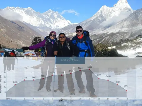
The Annapurna Circuit Trek altitude is both the greatest challenge and the most rewarding aspect of this legendary Himalayan journey. As a trekking co...
The wind carries ancient Buddhist prayers across frozen passes. Prayer flags snap against a cobalt sky. Your boots crunch through fresh snow at 5,000...
