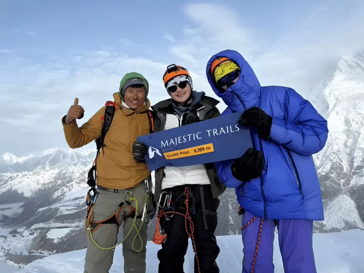
The Everest Base Camp with Island Peak Trek combines a classic high-altitude trek through Nepal’s Khumbu region with a technical climb to the summit of Island Peak (Imja Tse) at 6,189 meters (20,305 feet).
The Everest Base Camp with Island Peak Trek is a 19-day guided trek to Everest Base Camp (5,364 m) and Kala Patthar (5,545 m), followed by a climb of Island Peak, also called Imja Tse (6,189 m), in the Imja Valley. No mountaineering experience is required. You do need good physical fitness, because summit day takes 10 to 12 hours across a glacier, up fixed ropes and over a steep snow headwall.
Included
Included
When you hear about trekking to Everest Base Camp and peak climbing, it automatically triggers your adrenaline and scares you, right? Well, not anymore. We have a perfect package for you: Everest Base Camp with Island Peak Climbing. The journey to Everest Base Camp and the summit of Island Peak isn't just a journey - it's a thrilling odyssey through the heart of the Himalayas.
Everest Base Camp Hike with Island Peak Climbing explores prominent mountains for all interested mountaineers and also for beginner climbers on this alpine style of a day climb from the base or advance high camp.
Island Peak climb (6189m), also popular as Imja Tse, which, by its name, looks similar to an island in a sea of ice is an expansion of the edge coming down to the southern tip of Lhotse Shar. It is set in the heart of the Khumbu region and presents moderate challenge for mountaineers. Unforgettably, you will get to discover one of the best views in the world, including the views of Lhotse, Nuptse, Makalu, Baruntse, Ama Dablam etc. From the summit of the peak.
Along the way, the Everest Base Camp trek offers an opportunity to explore the iconic base camp of the world's highest mountain and enjoy breathtaking Himalayan scenery. If you are looking for the thrill of adventure with trekking and peak climbing in Nepal, Everest Base Camp with Island Peak Climbing is the perfect choice.
Just let Majestic Trails Nepal know about it if you are interested in Island Peak Climbing with Everest Base Camp Trek. We will rightly plan the trip in the best feasible way, satisfying all your needs.
This trek suits fit trekkers who want to stand on a Himalayan peak, not just look at one. Everest Base Camp is a trek; Island Peak is a climb. EBC with Island Peak combines the two, so the first ten days feel like our 14-day Everest Base Camp Trek, and the last week feels like a small mountaineering expedition.
The trekking section follows established teahouse trails with no technical terrain. The climbing section does not. Above base camp, you scramble up a rocky gully and rope up on a crevassed glacier. You cross ladders where the crevasses open, then climb a snow and ice headwall on fixed lines to a narrow summit ridge. The Nepal Mountaineering Association (NMA) classifies Island Peak as a trekking peak, and climbers typically rate the standard route PD+ on the Alpine scale. Simply put, it is not technical by mountaineering standards, but it is steep, cold and exposed enough that the training day is essential.
Book this trip if you have completed at least one multi-day trek and can hike 6 to 8 hours two days in a row. You should also be comfortable with some exposure. If you have never trekked at altitude, start with Everest Base Camp on its own and come back for the peak.
Climbing Island Peak after Everest Base Camp gives your body ten days to acclimatize before summit night. This matters, because altitude, not technique, turns most climbers back.
By the time you reach Chhukung (also spelled Chukhung), you have slept at Gorak Shep (5,164m) and stood on Kala Patthar (5,545m). The summit of Island Peak is only about 650m higher than Kala Patthar. Compare that with flying to Lukla and hiking straight up the Imja Valley, where your first night above 5,000m comes just before the climb.
There is also a practical reason. On EBC with Island Peak, you fly to Lukla once. Adding Imja Tse to Everest Base Camp costs about five extra days, not a second trip to Nepal.
Your journey begins in the arrivals area at Tribhuvan International Airport, where a Majestic Trails Nepal team member will be waiting outside the terminal with your name on a sign. The drive to your 3-star hotel in Thamel takes 20 to 40 minutes, depending on traffic.
If you arrive before noon, we meet the same day for a first gear check and paperwork. If you arrive later, rest, and we start fresh in the morning. Bring your passport, two passport-size photos, and a printed copy of your travel insurance policy. Your climbing permit and our emergency file both need them.
Use the evening to prepare. Withdraw or exchange Nepali rupees in Thamel, and buy a local SIM card from Nepal Telecom or Ncell with your passport. Eat a simple dinner, drink plenty of water and go to bed early. Tomorrow is a full day, and the morning after starts before dawn.
This is the day that sets Everest Base Camp with Island Peak apart from a standard trek. On a trek to Everest Base Camp, you can fly to Lukla the morning after you land. A climb cannot, because the permit, the gear and the briefing all need a full day.
The morning begins at our Thamel office with the trip briefing. Your trekking guide walks you through the route, the acclimatization rules, the evening oxygen checks, the summit-day plan and the turnaround rule. Ask everything now, while you are warm and well rested. Then we submit your Island Peak permit through the Nepal Mountaineering Association.
If the day finishes early, Boudhanath Stupa is a short taxi ride from Thamel. Eat early and go to bed early, because Ramechhap departures leave the hotel in the early hours of the morning.
Today you fly into the Khumbu and hike a short, gentle first stage down the Dudh Koshi Valley.
During peak months, most Lukla flights depart from Manthali Airport in Ramechhap, so you leave Thamel at around 1 to 2 am. Off-season flights usually depart from Kathmandu. When flying from Kathmandu, sit on the left side of the plane for the best mountain views. Our guide to Lukla flights from Kathmandu and Ramechhap covers the full flight picture.
You land at Tenzing-Hillary Airport, one of the most talked-about runways in the world. It is 527 m long and climbs at an 11.7% gradient toward the mountainside, which helps small planes stop. Edmund Hillary supervised its construction in 1964, and Nepal renamed it for Tenzing Norgay and Hillary in 2008.
Breakfast is in Lukla while your porters weigh and pack the loads. On the edge of town you pass the checkpoint of the Khumbu Pasang Lhamu Rural Municipality, named after Pasang Lhamu Sherpa, the first Nepali woman to climb Everest, in 1993. Your guide pays the municipality fee here.
The trail descends gently past Chheplung, where the path from Chaurikharka joins, then passes through Thado Koshi and Ghat. Here you meet your first long mani walls of carved prayer stones and your first prayer wheels. Pass them on the left so they stay on your right, as Sherpa families do. Kusum Kangguru rises above the far side of the valley. Phakding sits beside the river, and tonight you sleep lower than Lukla, the gentlest possible start for your body.
After dinner, your guide takes the first pulse oximeter reading. It sets the baseline for every check that follows.
Today brings the first real climb of the trip: a morning by the river, a national park gate, a high bridge and the long hill to Namche Bazaar.
From Phakding, the trail crosses and recrosses the Dudh Koshi on steel suspension bridges hung with prayer flags, passing the villages of Toktok and Benkar. Thamserku (6,623m) fills the sky across the river. Yaks and dzos, a cross between yaks and cattle, carry loads on this stretch. When a train of them passes, step to the hillside, never to the downhill side.
At Monjo you enter Sagarmatha National Park, and your guide shows your permits at the gate. The park was established in 1976, covers 1,148 square kilometers and became a UNESCO World Heritage Site in 1979. Our guide to Sagarmatha National Park covers its wildlife and history. A short, steep descent then takes you to Jorsalle, the last village before Namche and the usual lunch stop.
After lunch, follow the river flats to the confluence of the Dudh Koshi and the Bhote Koshi and cross the Hillary Suspension Bridge, strung high above the water. Namche Hill begins on the other side: a steady climb of about 600m that takes 2 to 3 hours. Walk at a pace where you could still hold a conversation, because rushing this hill is one of the most common early mistakes on the trek. On a clear day, Everest appears for the first time partway up, its summit rising above the long ridge of Nuptse and Lhotse.
Namche Bazaar fills a horseshoe-shaped bowl on the mountainside, its lodges stacked in terraces. For generations it was the trading center where Sherpa villages met traders from Tibet. Today it has gear shops, bakeries, ATMs and the last wide selection of just about everything until you come back down.
Rest days in Namche are active days. You climb about 440m in the morning, spend time at that altitude, and then come back down to sleep. This is how your body learns to work in thinner air.
The trail climbs steeply from the top of town, past the Syangboche airstrip, to Hotel Everest View (3,880m). Japanese entrepreneur Takashi Miyahara built it, and it opened in 1971. Guinness World Records listed it in 2004 as the highest hotel in the world. Order tea on the terrace and look up the valley: Everest, Lhotse, Ama Dablam (6,812m), Thamserku and Kangtega line up in front of you.
If the group feels strong, your guide can extend the loop to Khumjung (3,790m) and its neighbor Kunde, two Sherpa villages below Khumbila. Local people regard the mountain as the home of the Khumbu’s protector deity. Edmund Hillary’s Himalayan Trust built the Khumjung School in 1961, and the village monastery keeps a purported yeti scalp. Read more about the Sherpa people and Everest.
Spend the afternoon in Namche. The Sherpa Culture Museum, above town, displays clothing, tools, religious paintings and photographs of Everest expeditions going back to the 1950s. A few minutes away, past the army camp, the Sagarmatha National Park Visitor Center explains the park’s wildlife and culture and has one of the best Everest viewpoints in town. If you are here on a Saturday, visit the weekly market, where Khumbu families buy and sell yak cheese, butter and crops.
Your guide continues the evening oxygen and symptom checks that began in Phakding.
Today’s hike gives the best views for the effort on the lower trail: a level balcony path, a drop to the river and a forest climb to the Khumbu’s largest monastery.
You leave Namche on the high trail around the hillside toward Kyangjuma and Sanasa. Ama Dablam stands straight ahead, and Everest and Lhotse appear at the head of the valley. Watch the slopes for the danphe, or Himalayan monal, Nepal’s national bird, and for the Himalayan tahr, a wild goat, on the crags above the trail.
From Sanasa the trail drops steeply to Phunki Tenga, a few lodges beside the Dudh Koshi at about 3,315m. Have lunch, then show your permits at the army checkpoint just past the bridge. The climb to Tengboche takes about 2 hours and gains about 550m through pine, fir and rhododendron forest, which flowers red and pink in spring.
Tengboche Monastery is the largest gompa in the Khumbu. Lama Gulu built it in 1916. The 1934 earthquake destroyed it, and an electrical fire burned it down again in 1989. Volunteers and international donors helped rebuild it, and it was consecrated again in 1993. Every fall, usually in October or November, the monks hold the Mani Rimdu festival, with masked dances in the courtyard. Let us know when you book if you would like your dates to overlap with it.
If you arrive in time, sit in on the monks’ prayers. Take off your shoes, keep quiet and do not take photos inside the prayer hall. At sunset, walk to the edge of the meadow and watch the last light leave Ama Dablam and Everest.
Today you cross the tree line into the high Imja Valley, where Island Peak first comes into view.
The morning begins with a descent through birch, fir and rhododendron to Deboche, then crosses the Imja Khola on a suspension bridge above a narrow gorge. A steady climb takes you to Pangboche, at about 3,985m. Its monastery is one of the oldest in the Khumbu, and local tradition credits its founding to the Tibetan lama Sangwa Dorje. It once kept the “Pangboche Hand,” a relic said to belong to a yeti. Later analysis showed the bones were human, and the relic was stolen decades ago. Pangboche is also where Ama Dablam climbers turn off for their base camp.
Above Pangboche, past the small settlements of Somare and Orsho, the trees give way to juniper scrub and open yak pasture. Beyond Orsho, the trail divides. The left branch goes to Pheriche; you take the right branch into the Imja Valley.
Dingboche spreads across the valley floor in a patchwork of stone-walled fields of potatoes and barley. From here, Island Peak stands at the head of the valley, a pyramid of rock and snow beneath the south face of Lhotse. Afternoon wind is common, so reach the teahouse, add a warm layer and keep drinking. From now on, aim to drink 3 to 4 liters of fluid a day.
This is your second rest day, and the one cheaper itineraries cut. You climb above 5,000m for the first time, then sleep about 670m lower.
Nangkartshang is the long ridge rising directly behind Dingboche, between the Imja Valley and the Pheriche Valley. The trail is steep and rocky but not technical, and you climb slowly, with frequent stops. The goal is not the top. The goal is time spent high, so your guide decides when the group turns back.
On a clear morning, the view is one of the widest of the trip. Makalu (8,485m), the world’s fifth-highest mountain, appears to the east. Lhotse, Ama Dablam and Island Peak fill the near skyline, and Lobuche East, Taboche and Cholatse rise above the Pheriche Valley to the west.
Back in Dingboche, eat a big lunch and rest. Temperatures drop quickly once the sun leaves the valley, so use the warm hours to wash socks, charge batteries and nap. The Himalayan Rescue Association aid post at Pheriche, in the next valley, has treated trekkers for altitude illness since the 1970s. Your guide knows the quickest route there if anyone needs it.
Today you climb into the stony country of the Khumbu Glacier and pass the trail’s most moving landmark.
The trail climbs out of Dingboche onto a broad plateau above Pheriche. For a long stretch you walk almost level across yak pastures, with Taboche and Cholatse to your left and Lobuche East ahead. Dughla, at about 4,600m, is a small group of lodges at the foot of the Khumbu Glacier’s terminal moraine and the usual tea stop.
From Dughla, a steep climb of about an hour leads to Thukla Pass, at about 4,830m. Here, among prayer flags, stand dozens of stone memorials to climbers who died on Everest and nearby peaks, including the American guide Scott Fischer and Babu Chiri Sherpa. Give yourself a few quiet minutes.
The last stretch follows the moraine beside the Khumbu Glacier to Lobuche, with Nuptse (7,861m) towering to the east. If you still have energy, the Pyramid, an Italian-run research center in a glass pyramid at 5,050m, sits about 15 to 20 minutes up a side valley. It opened in 1990 to help measure the heights of Everest and K2, and scientists now use it to study glaciers, weather and earthquakes.
Nights in Lobuche are cold. Sleep in your base layers and keep your water bottles inside your sleeping bag so they do not freeze.
This is the day the trek has been building toward: a morning hike to the last settlement, then Everest Base Camp on the ice of the Khumbu Glacier.
Leave Lobuche early, while the ground is frozen and the air is still. The trail follows the lateral moraine of the Khumbu Glacier, rising and falling over scree and side streams, with Pumori (7,161m) ahead. After 2 to 3 hours you reach Gorak Shep, a few lodges on the edge of a frozen lakebed covered in sand. The name is usually translated as “dead ravens.” Swiss climbers used this spot as their base camp in 1952, before later expeditions moved closer to the mountain.
Drop your pack, eat an early lunch and carry only water, snacks and layers. The trail to base camp follows the moraine and then goes onto the glacier itself, past ice pinnacles and gray rubble. It gains little height, but the constant ups and downs at 5,300 m make it hard work. After about 2 hours, you reach Everest Base Camp, marked by prayer flags and a painted rock, directly beneath the Khumbu Icefall. Read more about Everest Base Camp height and what to expect.
Everest’s summit is hidden from base camp behind its West Shoulder and Nuptse. What you see instead is the icefall tumbling toward you, with Khumbutse, Lingtren, Pumori and Nuptse all around. In April and May, expedition tents spread across the glacier. In autumn, base camp is usually empty and quiet. Walk back to Gorak Shep for the highest night of the trek.
Today gives you the best Everest view of the trek at dawn and the longest descent so far by afternoon.
You leave Gorak Shep at around 4 to 5 am by headlamp. Kala Patthar means “black rock” in Nepali. It is a dark spur on the south ridge of Pumori, rising almost 400 m above the lodges, and the climb takes about 2 hours on a steep, sandy path. Go slowly. The cold before sunrise is the sharpest of the trek so far. Wear your down jacket, warm gloves and a hat, and keep your phone inside your jacket to protect the battery.
From the top, Everest stands clear above the Khumbu Icefall, with Nuptse and Lhotse beside it and the Khumbu Glacier curving below. The sun rises behind Everest, so the summit first appears as a dark pyramid edged with light, then the glow spreads down Nuptse and across Pumori behind you. Read why Kala Patthar is the best viewpoint of Mount Everest.
Back at Gorak Shep, eat a hot breakfast, then retrace your steps past Lobuche and down over Thukla Pass. Below Dughla, leave the Pheriche trail and take the high trail back to Dingboche. Sleeping more than 1,100m below Kala Patthar helps you recover, and Dingboche puts you at the mouth of the Imja Valley for tomorrow.
Today is short on purpose. You move about 320 m higher, rest, and meet the mountain you came to climb.
The trail follows the Imja Khola up a wide valley of yak pastures and stone herders’ huts. Ama Dablam rises on your right. On your left, the south face of Lhotse (8,516m), the world’s fourth-highest mountain, forms a wall of rock and ice. Island Peak grows bigger with every step. Chhukung (also spelled Chukhung), the last settlement in the valley, is a handful of lodges you usually reach by lunch.
Your climbing guide joins the team here. In the afternoon they check your boots and crampons, talk you through the climb and answer your questions while you sit in a warm dining room. Mountaineering boots can usually be rented in Chhukung if you did not bring your own.
Rest is the main job. If you feel strong and your guide agrees, walk part of the way up the slopes toward Chhukung Ri (5,550 m) and come back down. Most climbers save their legs. Drink well and eat a big dinner.
Today you hike to base camp, settle into your tents and spend the afternoon learning the skills you will need on summit day.
The trail follows the moraine above the Imja and Lhotse Shar glaciers to the sandy flats called Pareshaya Gyab, where base camp sits. At the snout of the Imja Glacier lies Imja Tsho, a lake that began forming in the 1950s. An outlet built in 2016 lowered it to reduce the risk of a flood downstream. Our team pitches twin-share tents, a dining tent and a toilet tent, and the cook takes over the meals.
After lunch, your climbing guide runs a training session on real slopes near camp. You fit and walk in crampons, clip into a fixed line, climb with an ascender, descend with a belay device and cross a ladder. Your guide also explains how rope teams move on a glacier and the signals the team will use on the mountain. Repeat each move until it feels routine; on a cold headwall above 6,000m, routine is what you want.
Before dinner, pack your summit bag. It holds two insulated bottles of hot water, snacks you will actually eat in the cold, your down jacket, warm gloves and spare mittens. Add a headlamp with fresh batteries, glacier glasses and sunscreen. Lay out your harness, already adjusted. Dinner is early, and most climbers are in their sleeping bags by 7 pm.
Some operators move up to a high camp to shorten summit morning. We sleep at base camp as standard, because a lower night usually means better rest before the hardest day. A night at high camp is available on request.
Summit day is a pre-dawn start, a glacier, a headwall and a ridge, followed by a long walk down. The summit-day section gives the hour-by-hour plan.
You leave camp between 1 and 2 am in a line of headlamps. The trail climbs the moraine, then a rocky gully with easy scrambling. At crampon point, on the edge of the glacier, you stow your trekking poles, step into your crampons and rope up with your climbing guide. The glacier crossing winds between crevasses and, depending on the season, over aluminum ladders.
Then the headwall rises in front of you, about 100 to 150 m of steep snow and ice. You clip your ascender to the fixed line and settle into a rhythm: slide, step, breathe. At the top, a short, narrow and exposed ridge leads to the summit. The south face of Lhotse towers above, Makalu, Baruntse and Ama Dablam rise across the skyline, and Imja Tsho lies far below.
Coming down, you descend the headwall on the fixed rope, recross the glacier and reach base camp for a hot drink. Then you pack up and walk down to Chhukung for a proper bed. The turnaround time your guide set the evening before is the one rule that never bends. Climbers who reach the summit receive a summit certificate.
The weather on Island Peak can change quickly. If wind, fresh snow or a sick team member stops the Day 14 attempt, we use this day to try again. In that case, you spend a second night at base camp instead of walking down, and climb the next morning.
If you summit on Day 14, the spare day goes where it helps you most. Usually that means splitting the long descent into two easier stages with a night in Pangboche or Tengboche, where the thicker air brings the best sleep in two weeks. Or we keep it in hand as a spare day for Lukla flights.
Today is a long, mostly downhill day that drops you almost 1,300m into thicker air.
You walk back down the Imja Valley through Dingboche, then follow the river past Orsho, Somare and Pangboche. After crossing the Imja Khola below Deboche, you make a short climb to Tengboche for lunch, then descend steeply through the forest to Phunki Tenga. One last climb takes you up to Kyangjuma, and the balcony trail carries you around the hillside into Namche. Trekking poles will save your knees today.
Namche feels different on the way down. The air is thick, the bakeries are open and a hot shower is easy to find. If you used Day 15 to sleep lower, today shortens to about 4 hours.
The last walking day retraces the Dudh Koshi to Lukla.
Descend Namche Hill, cross the Hillary Suspension Bridge and follow the river through Jorsalle to Monjo, where you show your permits as you leave the national park. Lunch is usually in Phakding. The final 2 hours climb gently back up through Ghat and Chheplung to Lukla, where the trek began.
Tonight is the farewell to your trekking crew and porters. Most groups hand over tips here, separately for each team member, and we share a suggested range at the Day 2 briefing. Your guide reconfirms your morning flight.
Flights leave Lukla in the morning, when the wind is usually calmest. If weather grounds the morning flights, Day 19 gives you a fallback, so book your flight home for Day 19 or later. If delays run long, a helicopter flight is possible at extra cost.
Back in Kathmandu, enjoy a long shower, collect your stored luggage and spend the afternoon in Thamel. We close the trip with a farewell dinner in the evening.
We drive you to Tribhuvan International Airport about 3 hours before your international flight. If you are staying on, we can add a Kathmandu city tour or extra nights in the valley.
The 19-day plan above is our standard for Everest Base Camp with Island Peak. These are the changes climbers ask for most often:
Cross the Kongma La (5,535m). Strong, well-acclimatized trekkers can walk from Lobuche to Chhukung over the highest of the Everest region’s three passes instead of descending to Dingboche. It is a long, hard day on rough ground. Our 3 Passes Trek shows the full three-pass route.
Add the Gokyo Lakes. Starting with the Gokyo Valley adds a few days and extra acclimatization before Everest Base Camp. Our Gokyo and Renjo La Pass Trek covers that side of the Khumbu.
Sleep at high camp. A night higher on the mountain shortens summit morning, in exchange for a colder and less comfortable night.
Fly out by helicopter. After the summit, a helicopter from the Imja Valley to Lukla or Kathmandu saves three days of walking down. See our helicopter tours in Nepal and ask for the current fare.
Add days in Kathmandu. A city tour fits easily before or after the climb.
Choose a private trip. Each of the options above works on a private trip, on dates that suit you.
Contact us to plan your version.
Island Peak is a 6,189-meter trekking peak in Sagarmatha National Park, at the head of the Imja Valley above Chhukung in Nepal’s Solukhumbu District. It is not a separate mountain so much as the end of a ridge that runs south from Lhotse Shar.
Most operators quote 6,189 m (20,305 ft). The Nepal Mountaineering Association, which issues the climbing permit, lists 6,160 m on its peak register and 6,165 m on its fee schedule. The government’s Nepal Himal Peak Profile also gives 6,165 m. We use 6,189 m because it is the figure on almost every trip page and summit certificate, but the official register is slightly lower.
Members of the 1953 British Everest expedition named it Island Peak because, seen from Dingboche, it rises like an island in a sea of ice. A team including Tenzing Norgay, Charles Evans, Alfred Gregory and Charles Wylie climbed the southwest summit that year as training for Everest. A Swiss team made the first ascent of the main summit in 1956. The peak was renamed Imja Tse in 1983, but climbers still call it Island Peak.
Everest stands only about 10 km to the north, yet the wall of Lhotse, roughly 2,300 m higher than the summit, hides most of it. Your best Everest views come earlier, from Kala Patthar. From the top of Island Peak you look straight up at Lhotse and across to Makalu, Baruntse and Ama Dablam.
Summit day on Island Peak usually takes 10 to 12 hours from base camp and back, starting between 1 and 2 am. Times shift with the weather, snow and group pace, but a typical day runs like this:
From base camp at about 5,087m, you climb roughly 1,100m to the summit, and the round trip covers about 11km. On busy mornings, queues can form at the fixed ropes, so your climbing guide sets the start time and a firm turnaround time at base camp the evening before.
Everest Base Camp with Island Peak is strenuous. The trekking half is moderate to hard because of the altitude. The climbing half adds a middle-of-the-night start, a crevassed glacier and a steep headwall on fixed ropes above 6,000m, where every step takes real effort.
You will walk 5 to 8 hours on most days for 15 days, and summit day lasts 10 to 12 hours. Night temperatures at base camp and on the summit push can drop to around -20°C, colder with wind.
Think twice if you have never trekked at altitude, have a heart or lung condition without medical clearance, or cannot commit to training. Our guide Can a normal person do Everest Base Camp? helps you judge the trekking half honestly.
Give yourself 12 weeks. Fitness gets you to base camp; skills make summit day calm.
Everest Base Camp with Island Peak requires three permits, and we arrange all three: the NMA Island Peak climbing permit, the Sagarmatha National Park entry permit and the Khumbu Pasang Lhamu Rural Municipality fee.
Fees verified 2026 Oct:
| Permit | Fee for Foreign Nationals | Where It Is Issued |
|---|---|---|
| NMA Island Peak Climbing Permit | US$350 in spring (March–May); US$175 in summer, autumn, and winter | Nepal Mountaineering Association (NMA), Kathmandu, through a registered agency |
| Sagarmatha National Park Entry Permit | NPR 3,000 | Lukla or Monjo Park Gate |
| Khumbu Pasang Lhamu Rural Municipality Fee | NPR 3,000 | Lukla |
You do not need a TIMS card in the Khumbu. The rural municipality fee replaced it in 2018, and sites that still list TIMS for the Everest region are out of date. Our Everest Base Camp permit guide covers checkpoints and payment.
Island Peak permits are applied for through a registered trekking agency, not by individual climbers, which is why permit processing takes place on Day 2 in Kathmandu. The NMA spring royalty has long been about double the fall rate.
The best months to climb Island Peak are April, May, October and November.
For month-by-month details on the trekking section, read our guide to the best time to trek to Everest Base Camp.
During busy months, the Civil Aviation Authority of Nepal moves most scheduled Lukla flights from Kathmandu to Manthali Airport in Ramechhap to ease congestion at Tribhuvan International Airport.
For you, this means a hotel pickup around 1 to 2 am, a drive of about 4 to 5 hours and a short flight. We include the transfer and confirm your departure airport before you arrive, because airlines can change their arrangements from season to season. Shared or private helicopters from Kathmandu to Lukla skip the drive at extra cost; ask us for the current fare.
The usual Lukla baggage allowance is 15 kg, including hand luggage. Mountaineering boots are heavy, so many climbers rent them in Chhukung instead of flying them in.
You sleep in a 3-star hotel in Kathmandu, family-run teahouses on the trail and a tented camp for one night at Island Peak Base Camp. Rooms are twin-share with simple beds and blankets. Up to Namche, many lodges offer attached bathrooms; higher up, toilets are shared and often squat style. Dining rooms are heated by a stove in the evening, while bedrooms stay cold, so a good sleeping bag is essential. Read more about teahouses on the Everest Base Camp trek.
Teahouse menus include dal bhat, noodle soup, momos, potatoes, eggs, porridge and pancakes, and dal bhat comes with refills. Above Namche we advise a vegetarian diet, because meat is carried up for days without refrigeration. Vegetarians and vegans eat well on this route; gluten-free hikers should carry extra food.
Bring two insulated 1-liter bottles and treat your water with tablets, a filter or boiled water from the teahouse. Plastic bottled water is discouraged in the Khumbu, and refilling is cheaper. On summit night, carry warm water in an insulated bottle, because hydration hoses freeze.
Carry Nepali rupees in cash for teahouse extras such as hot showers, charging, Wi-Fi, snacks and drinks. ATMs in Lukla and Namche can run out of cash or fail, so withdraw the money you need in Kathmandu.
Most teahouses charge per device to charge batteries, and power higher up often comes from solar panels. The cold drains batteries quickly, so sleep with your phone and power bank inside your sleeping bag. Nepal uses Type C and Type D sockets; a universal adapter covers both.
Paid Wi-Fi is available at most teahouses, but it slows down as you climb. Mobile signal covers much of the lower route and becomes patchy higher up. Your guide carries satellite communication for emergencies.
Our Everest Base Camp trek and Island Peak climbing adventure with Majestic Trails Nepal was an unforgettable experience. Our guide, Bibek Dhamala, made the entire journey smooth, enjoyable, and well organized. From the trails to high-altitude climbing preparation, everything was handled professionally. What impressed us most was the team's knowledge of the mountains, attention to acclimatization, and support during the challenging summit push. The guides were patient, encouraging, and always focused on making sure we understood the next step. Reaching Island Peak after trekking to Everest Base Camp was a dream come true. If you are looking for a reliable local trekking company in Nepal for Everest Base Camp and Island Peak, Majestic Trails Nepal is worth considering. Their personal approach and experienced mountain team made a real difference.
Mera Peak is higher (6,476m) but less technical, so it suits strong trekkers who have never used crampons. Island Peak (6,189m) is lower but has a steep snow and ice wall on fixed ropes, so it suits climbers who want a more technical first summit and the Everest Base Camp trek in the same trip.
Yes. You can book any climbing package as a solo climber with a private licensed climbing guide; the price per person is higher than in a group.