
Trekking to Everest Base Camp in December: A Quiet Winter Journey
16 Jan 2026
IntroductionNepal — the final destination for every mountaineer. A place where almost everyone dreams of going at least once in their lifetime. To see...

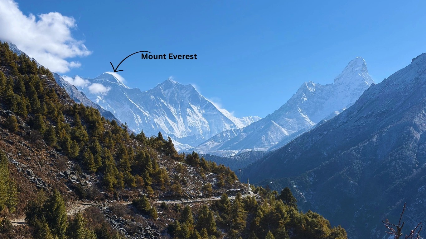
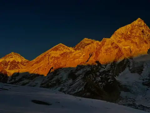
Stand at the edge of the Khumbu Valley on a clear October morning, and the world stops making sense in the best possible way. The silence is absolute. The air is thin and cold and clean. And above it all — impossibly high, etched against a sky so blue it almost hurts — rises the summit of Mount Everest. This is Sagarmatha National Park: a place that rewrites your understanding of scale, nature, and human resilience all at once.
Whether you're a first-time trekker dreaming of Everest Base Camp or a seasoned adventurer plotting the Three Passes, this guide covers everything you need before you lace up your boots. We'll walk you through the park's history, how to get here from Kathmandu, which permits you need (and which ones you no longer need — yes, we're looking at you, TIMS card), the best trekking routes, wildlife you might encounter, where to sleep, and exactly when to go. Let's get into it.
Sagarmatha National Park is Nepal's most celebrated protected area and the world's highest national park, home to the iconic Mount Everest — known in Nepali as Sagarmatha, meaning "forehead of the sky." Stretching across the upper reaches of the Solukhumbu District in northeastern Nepal, the park is not just a gateway to the planet's tallest peak; it is a living tapestry of Sherpa culture, high-altitude biodiversity, and raw Himalayan beauty that has captivated the world for generations.
In 1979, just three years after its founding, Sagarmatha National Park was inscribed as a UNESCO World Heritage Site — a recognition not only of its spectacular mountain landscape but of the extraordinary cultural heritage of the Sherpa people who have called this region home for centuries.
When was Sagarmatha National Park established? Sagarmatha National Park was officially established on July 19, 1976, under Nepal's National Parks and Wildlife Conservation Act of 1973. It became Nepal's third national park and was inscribed on the UNESCO World Heritage List just three years later, in 1979, in recognition of its outstanding natural and cultural significance.
Sagarmatha National Park is located in the Solukhumbu District of northeastern Nepal, within the Khumbu region of the Himalayas. It lies approximately 140 km northeast of Kathmandu (straight-line distance) and shares its northern boundary with Tibet (China). The park spans elevations from roughly 2,300 m to 8,848.86 m above sea level.
More specifically, the park occupies the upper Khumbu Valley — one of the most dramatic landscapes on Earth. Its northern boundary runs along the Himalayan divide, bordering the Tibet Autonomous Region of China. To the south, the park transitions into the buffer zone of Sagarmatha National Park, a protected peripheral area that connects the core park with surrounding human settlements and helps manage ecological and tourism pressures.
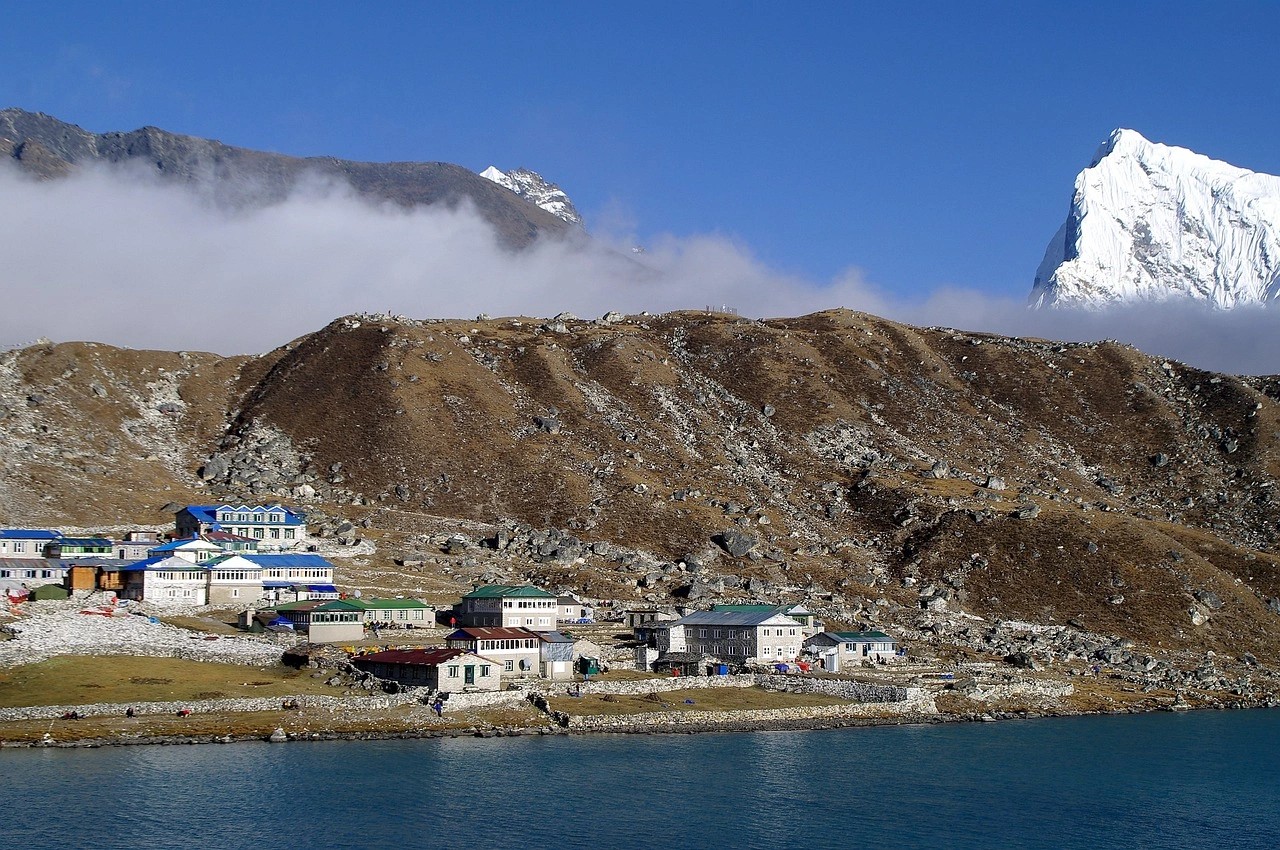
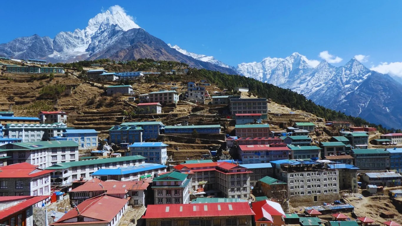
Within these boundaries you'll find the world-famous Khumbu Glacier, the Dudh Koshi River valley, towering peaks including Lhotse (8,516 m), Cho Oyu (8,188 m), and Ama Dablam (6,812 m), and the bustling highland market town of Namche Bazaar, which serves as the park's de facto capital and the main hub for trekkers and climbers alike.
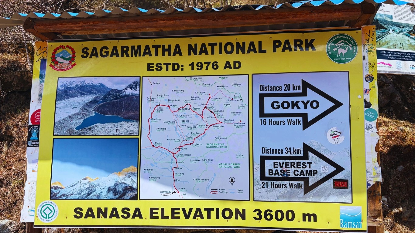
The sagarmatha national park map shows a broadly rectangular protected area laced with trekking trails radiating outward from Namche Bazaar. Key features visible on the map include the entrance checkpoints at Monjo and Jorsalle, the Gokyo valley to the west, the Everest Base Camp route to the north, and the Three Passes circuit that loops the entire park. Several entry and ranger stations are marked, along with altitude profiles and glacier extents.
The geological story of Sagarmatha National Park stretches back 50 million years — to the slow-motion collision of the Indian and Eurasian tectonic plates that thrust the Himalayan range skyward. The peaks we see today, including Everest itself, are still technically rising a few millimetres each year. The Khumbu Glacier, one of the world's highest glaciers, carved the valley floors that trekkers now walk through every autumn and spring.
Culturally, the history of Sagarmatha National Park is inseparable from the Sherpa people, who migrated from eastern Tibet roughly 500 years ago and settled in the Khumbu region. They brought Buddhism with them, establishing monasteries at Tengboche and Thame that still anchor the spiritual life of the valley. Sherpa expertise in high-altitude mountaineering became world-famous after Tenzing Norgay summited Everest alongside Edmund Hillary in 1953 — an event that put the Khumbu on the global map.
Formal conservation came two decades later. Nepal's government passed the National Parks and Wildlife Conservation Act in 1973, and Sagarmatha National Park was gazetted under it in 1976, with New Zealand providing advisory support. The park's UNESCO World Heritage listing followed in 1979 — making it the first Himalayan national park to receive this honour.
When was Sagarmatha National Park enlisted in the World Heritage List? Sagarmatha National Park was inscribed on the UNESCO World Heritage List in 1979 — just three years after its establishment. UNESCO recognised it for its exceptional natural beauty, outstanding geological features, and the unique cultural heritage of the Sherpa people who inhabit the Khumbu region.
Getting here is part of the adventure. Whether you fly above the clouds to a legendary mountain airstrip or take a rugged overland route through terraced hillsides, the journey to the park's entrance is memorable in its own right.
The overwhelming majority of trekkers fly from Kathmandu's Tribhuvan International Airport to Tenzing-Hillary Airport in Lukla (elevation: 2,860 m). The flight takes approximately 35–40 minutes and is operated by several carriers including Tara Air, Summit Air, and Sita Air. Be prepared: it's one of the most spectacular — and meteorologically unpredictable — flights in the world. Pilots land on a short uphill runway with a cliff on one end and a mountain wall on the other.
Book your Lukla flight at least 3–4 weeks in advance during peak season (March–May, September–November). Flights cancel frequently due to weather. Always build two buffer days into your Kathmandu itinerary for the return leg — we've seen trekkers miss international connections because of fog. Our team at Majestic Trails Nepal monitors weather forecasts and can advise on timing.
From Lukla, it's a 3-day walk to Namche Bazaar and the park's main entrance checkpoint at Monjo/Jorsalle. The trail through Phakding and along the Dudh Koshi river is gorgeous — waterfalls, suspension bridges, rhododendron forests.
A growing number of budget travellers and those who dislike flying opt for the overland route: Kathmandu → Salleri or Phaplu by jeep or local bus, then trekking the remaining distance to Lukla and beyond. The road journey takes roughly 10–14 hours depending on conditions and the route taken. From Phaplu (where there is also a small airstrip), it's a 3–4 day walk to reach the national park entrance. It's a longer and more physically demanding approach, but it offers a genuine sense of the landscape — terraced rice paddies, villages, and the gradual ascent into alpine terrain.
The straight-line (aerial) distance from Kathmandu to the park's southern boundary near Jorsalle is approximately 140 km. However, by road it expands to roughly 500 km via the winding mountain highways. By air (Kathmandu–Lukla flight) you cover about 135 km in under 40 minutes; then it's another 35 km of trekking trail to Namche Bazaar.
There is no direct route from Pokhara to the park. Travellers must first travel to Kathmandu — approximately 200 km by road (6–7 hours) or 25 minutes by air — and then follow the Kathmandu-to-Lukla route described above. Total road distance from Pokhara to the park entrance (via Kathmandu and the Salleri overland route) is roughly 700 km. Flying via Kathmandu remains by far the fastest and most practical option.
No — a guide is not strictly mandatory in the Sagarmatha National Park as of 2026. You can still trek independently if you have the required permits.
However, hiring a guide is strongly recommended for safety, navigation, and a better overall experience — especially on routes like Everest Base Camp or the Three Passes.
At Majestic Trails Nepal, all our guides are licensed by the Nepal Tourism Board, trained in wilderness first aid, and deeply familiar with the Khumbu region. Many of our Sherpa guides were born in the valley — their knowledge of these trails goes beyond any map.
Sagarmatha National Park is managed by Nepal's Department of National Parks and Wildlife Conservation (DNPWC). On the ground, the Sagarmatha Pollution Control Committee (SPCC) plays a critical operational role — managing waste disposal, enforcing environmental regulations, and coordinating with the Sherpa community on conservation and sustainable tourism initiatives.
The park operates under a co-management model that involves national government, local government (Khumbu Pasang Lhamu Rural Municipality), and community organisations. The SPCC — founded in 1991 — has been particularly instrumental in reducing the once-severe pollution burden on the trail. Trekkers are now required to carry out all non-biodegradable waste, and lodges are prohibited from burning plastics. Annual clean-up expeditions on Everest and surrounding peaks continue to remove decades of accumulated debris from high-altitude campsites.
As of 2026, trekking into Sagarmatha National Park requires two fees — and importantly, the TIMS card (Trekkers' Information Management System) has been officially abolished and is no longer required. Do not let any agent charge you for a TIMS card.
| Permit | Fee (USD / NPR) | Where to Obtain |
|---|---|---|
| Sagarmatha National Park Entry Permit | ~$30 / NPR 3,000 | Lukla or Monjo checkpoint |
| Khumbu Pasang Lhamu Municipality Fee | ~$20 / NPR 2,000 | Local checkpoints |
| TIMS Card | ❌ Not required (2026) | — |
It is strongly advisable to obtain your national park permit from the Nepal Tourism Board office in Thamel, Kathmandu, before you fly to Lukla — this saves time and avoids queues at the entrance. Keep your permit safe; rangers check it at multiple points along all major trails.
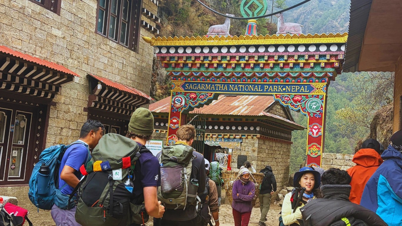
The primary Sagarmatha National Park entrance gate is located at the Monjo, approximately a 3-hour walk south of Namche Bazaar. This is the official entry point where rangers inspect all permits and log trekker details. Arriving without a permit here means a significant delay — and a fee that's still payable on-site, with a possible surcharge.
The Monjo checkpoint typically operates from early morning until around 5:00 PM. Most trekkers don't realise how important it is to reach this gate before closing time — arriving late could mean an overnight stay before being cleared to proceed. Plan to leave Phakding by early afternoon. Our guides always flag this to clients before the day begins.
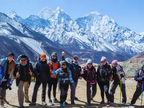
The park offers some of the most iconic trekking in the world. Whether you're drawn by the gravitational pull of Everest Base Camp, the turquoise stillness of the Gokyo Lakes, or the challenge of all three high passes, you'll find a route that matches your ambition.

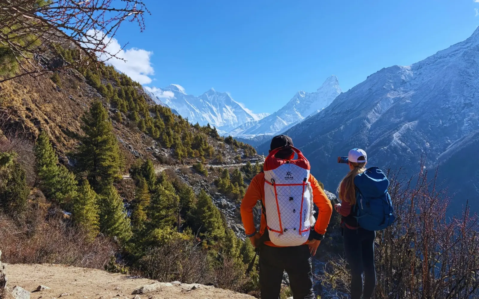
The Everest Base Camp (EBC) trek is the most famous multi-day hike in the world, and it runs entirely within Sagarmatha National Park. The classic route starts in Lukla and follows the Dudh Koshi River north through Phakding, Namche Bazaar (acclimatisation stop), Tengboche, Dingboche, Lobuche, and Gorak Shep before reaching Base Camp at 5,364 m. The round trip takes approximately 12–16 days.
Highlights along the way include the famous Saturday market at Namche Bazaar, the Tengboche Monastery with its spectacular Everest backdrop, and the surreal moonscape of the Khumbu Glacier terminal moraine. The final ascent to Kala Patthar (5,644 m) — optional but highly recommended — rewards you with arguably the best above-the-clouds view of Everest's south face on the planet. Explore our complete Everest Base Camp Trek guide →
What country is Gokyo Ri Sagarmatha National Park in? Gokyo Ri is located in Nepal — specifically within Sagarmatha National Park in the Solukhumbu District of northeastern Nepal. Gokyo Ri is a viewpoint peak rising to 5,357 m above sea level, offering panoramic views of four 8,000-metre peaks including Mount Everest, Lhotse, Makalu, and Cho Oyu.
Where is Gokyo Ri Sagarmatha National Park? Gokyo Ri is situated in the western arm of Sagarmatha National Park, in the Gokyo Valley of Solukhumbu District, Nepal. The viewpoint stands at 5,357 m and overlooks the Gokyo Lakes — a chain of six glacial lakes fed by the Ngozumpa Glacier, the longest glacier in the Himalayas.
If EBC is the headline act, Gokyo Lakes Sagarmatha National Park Nepal is the hidden gem. The Gokyo Valley offers fewer crowds, arguably more diverse scenery, and the Ngozumpa Glacier — the largest glacier in Nepal — flowing just metres from the trail. The six sacred turquoise lakes of Gokyo are a sight unlike anything else in the Himalayan ecosystem.
The ascent of Gokyo Ri (5,357 m) rewards trekkers with simultaneous views of Everest, Lhotse, Makalu, and Cho Oyu — four of the world's 14 eight-thousanders visible from a single vantage point. This makes Gokyo Ri the most panorama-rich viewpoint in the park.
The Three Passes Trek is the ultimate Khumbu circuit, crossing Renjo La (5,360 m), Cho La Pass (5,420 m), and Kongma La (5,535 m) in a 18–21 day loop that combines the EBC and Gokyo routes. It demands prior Himalayan trekking experience and strong fitness, but rewards you with an unrivalled sense of the park's full geography. Learn more about the Three Passes Trek →
Helicopter tours are available from Kathmandu or from within the valley (Namche to EBC flightseeing, for example), and are a growing option for travellers with limited time or those returning from a trek. They can also serve as emergency evacuation options — something worth knowing.
Even if you're not trekking far, Namche Bazaar itself is worth several days. The Saturday market, the maze of bakeries and gear shops, the Nepal Himalaya Cultural Heritage Museum, and the famous panoramic viewpoint above town are all rewarding. The Sagarmatha National Park Museum — located at the park headquarters in Namche — is a must-visit. It houses exhibits on local geology, Sherpa culture, mountain flora and fauna, and the history of Everest expeditions. Entry is included with your park permit. Open most days from 9 AM to 4 PM.
Timing is everything at altitude. The Khumbu region's weather is ruled by the South Asian monsoon and the Himalayan jet stream — and while the park is technically open year-round, the trekking experience varies dramatically by season.
| Season | Months | Weather | Note |
|---|---|---|---|
| Spring | Mar – May | Clear, blooming | ✅ Best |
| Monsoon | Jun – Aug | Rainy, cloudy | ⚠️ Avoid |
| Autumn | Sep – Nov | Clear, stable | ⭐ Best views |
| Winter | Dec – Feb | Cold, snowy | ⚠️ Experienced only |
Sagarmatha National Park temperature varies dramatically with altitude. In Namche Bazaar (3,440 m), expect daytime temperatures of 5–15°C in spring and autumn, dropping to around -5°C at night. At Everest Base Camp (5,364 m), daytime temperatures in spring range from -5°C to 5°C, while nights can plunge to -20°C or colder. Proper layering is non-negotiable. Weather above 5,000 m can change in minutes — blue skies can give way to snowstorms within the hour.
Most trekkers come for the mountains, but the park's biodiversity is quietly remarkable. The altitude gradient — from sub-alpine forest to permanent snow and ice — creates a stacked series of ecological zones, each with its own community of species adapted to extreme conditions.
The snow leopard is the park's most mythologised resident — secretive, perfectly camouflaged against grey rock, and genuinely rare to spot. Our guides have encountered tracks and, on a handful of unforgettable mornings, the animal itself, usually in the rocky terrain above Namche or near Gokyo. Your best chance is early morning in winter or early spring, scanning the ridgelines with binoculars above 4,000 m.
Other notable animals of Sagarmatha National Park include the red panda (found in the rhododendron and bamboo forests below 4,000 m — more common than most people realise), the Himalayan tahr (a stocky wild goat often visible on steep cliffs near Namche), musk deer, and the elusive Himalayan wolf. Blue sheep (bharal) are more commonly seen grazing the open slopes above Gokyo and Dingboche.
Birdwatchers are in for a treat. The park hosts over 150 bird species, including Nepal's national bird, the Impeyan pheasant (Danphe) — a spectacular, iridescent bird that flashes metallic green and blue on sunny mornings in the forest above Namche. The lammergeier (bearded vulture), with its near-3-metre wingspan, is a common and awe-inspiring sight soaring on thermals above the high valleys. Snow pigeons drift in flocks around the glaciers near Lobuche.
For birding, the stretch between Lukla and Namche Bazaar in early morning — particularly in spring — offers the best variety. The forests of rhododendron and fir in this zone support warblers, thrushes, and the elusive Himalayan monal in breeding plumage.
The lower reaches of the park are cloaked in dense rhododendron forests that burst into colour (pink, red, and white) between March and May. Above 3,500 m, juniper and birch dominate before giving way to alpine scrub and cushion plants near the moraines. Above 5,000 m, only mosses, lichens, and a handful of extraordinarily hardy flowering plants persist — adapted to UV radiation, freeze-thaw cycles, and soil that is barely more than crushed rock. The plants of Sagarmatha National Park represent one of the world's most complete altitudinal vegetation sequences, from warm-temperate forest to permanent ice.
The accommodation scene in the Khumbu is one of the most developed in the high Himalayan world, anchored by the famous Nepali teahouse system. Almost every village along the major trekking routes has a cluster of lodges offering a bed, a hot meal, and the warmth of a yak-dung or wood-burning stove.
Expect a basic private or shared room with a single or twin bed, blankets (bring a sleeping bag liner for hygiene), and shared bathrooms. Meals are served family-style in a communal dining room — dal bhat, pasta, soups, Tibetan bread, yak cheese, and surprisingly good coffee. Costs increase with altitude: a room that costs NPR 300–500 in Phakding might run NPR 600–1,000 in Gorak Shep, though the room quality at altitude is typically lower.
Luxury exists here too. Namche Bazaar and Phakding have several upscale lodges (think: heated rooms, attached bathrooms, espresso machines) that cater to the growing market of comfort-seeking trekkers. The Hotel Namche in Namche and the Yeti Mountain Home chain are popular mid-to-high-end options. Book these well ahead of time during peak season — availability goes fast.
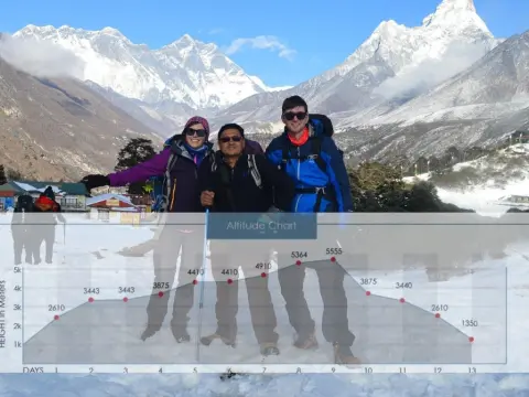
Key overnight stops and their approximate altitudes: Phakding (2,651 m), Namche Bazaar (3,440 m), Tengboche (3,867 m), Dingboche (4,410 m), Lobuche (4,940 m), Gorak Shep (5,164 m). For the Gokyo route: Dole, Machhermo, and Gokyo village itself.
Sagarmatha National Park is not just a destination — it's a reckoning with the sheer scale of the natural world. The glaciers, the silence, the sky above the clouds, the warmth of a teahouse fire after a long day on the trail — these aren't things you can prepare for fully. You have to go and feel them.
Whether you're drawn by Everest, by Gokyo's blue lakes, by the sight of a lammergeier hanging motionless above a glacial moraine, or simply by the desire to walk somewhere truly extraordinary — the Khumbu is waiting. And with the right preparation, the right guide, and this guide in your back pocket, you'll arrive ready for every moment of it.
Explore our handcrafted trekking packages — from classic Everest Base Camp journeys to remote Gokyo and Three Passes expeditions. All guided, all inclusive, all unforgettable.
At Majestic Trails Nepal, we've been guiding trekkers through the Khumbu since 2008 — long before the teahouses of Dingboche got espresso machines. We know which lodges keep their blankets clean, which trails get icy before sunrise in October, and how to spot a snow leopard track in the snow above Gokyo. That knowledge lives in our guides — most of whom grew up in these valleys.
We're a fully licensed Nepal Tourism Board operator committed to sustainable, community-driven trekking. Every trek we run contributes directly to local porter wages, lodge businesses, and community conservation funds. We don't just pass through the Khumbu — we're part of it. Whether you're planning your first Everest Base Camp trip or designing a bespoke three-pass expedition, our team is here to make it the experience of a lifetime.
Ready to start planning? Contact us for a custom itinerary or explore our Everest Base Camp packages — and let us show you the Himalayas the way they deserve to be seen.
Sagarmatha National Park is located in the Solukhumbu District of northeastern Nepal, within the Khumbu region of the central Himalayas. It borders Tibet (China) to the north and lies approximately 140 km northeast of Kathmandu in a straight line. The park's headquarters are in Namche Bazaar at 3,440 m above sea level.
Sagarmatha National Park was officially established on July 19, 1976, under Nepal's National Parks and Wildlife Conservation Act of 1973. It was the country's third national park. UNESCO added it to the World Heritage List in 1979, recognising its outstanding natural and cultural values.
The most popular route is a 35–40 minute flight from Kathmandu to Lukla (Tenzing-Hillary Airport), followed by a 3-day trek to the park entrance at Jorsalle/Monjo. An overland alternative involves a 10–14 hour jeep journey to Salleri or Phaplu, then several days of trekking. Most visitors choose to fly.
Yes. Since April 2023, Nepal requires all foreign trekkers in the Sagarmatha region to be accompanied by a licensed guide. Solo trekking is no longer permitted anywhere in the park. This rule covers all routes including Everest Base Camp, Gokyo Lakes, and the Three Passes Trek.
The park is managed by Nepal's Department of National Parks and Wildlife Conservation (DNPWC), in collaboration with the Khumbu Pasang Lhamu Rural Municipality and the Sagarmatha Pollution Control Committee (SPCC). The SPCC plays a central role in waste management, environmental enforcement, and sustainable tourism programmes.
Sagarmatha National Park was inscribed on the UNESCO World Heritage List in 1979 — just three years after its establishment in 1976. It was recognised for its exceptional natural scenery, high-altitude ecosystems, and the living cultural heritage of the Sherpa people of the Khumbu region.
Gokyo Ri is located in Nepal, within Sagarmatha National Park in the Solukhumbu District. It is a high-altitude viewpoint at 5,357 m in the Gokyo Valley, offering panoramic views of four 8,000-metre peaks: Everest, Lhotse, Makalu, and Cho Oyu.
Gokyo Ri lies in the western part of Sagarmatha National Park, in the Gokyo Valley, Solukhumbu District, Nepal. It overlooks the Gokyo Lakes chain and the Ngozumpa Glacier — the longest glacier in Nepal. The summit sits at 5,357 m and is reached via a 2–3 hour ascent from Gokyo village.
No. As of 2026, the TIMS card (Trekkers' Information Management System) has been officially abolished and is no longer required for trekking anywhere in Nepal, including Sagarmatha National Park. Trekkers now only need the Sagarmatha National Park entry permit and the Khumbu Pasang Lhamu Rural Municipality fee.
IntroductionNepal — the final destination for every mountaineer. A place where almost everyone dreams of going at least once in their lifetime. To see...
Standing face-to-face with Mount Everest doesn't require weeks of grueling trekking or extreme altitude exposure. The Everest View Trek Nepal offers o...
Kalapathar stands at 5,545 meters (18,192 feet) as the highest accessible viewpoint on the Everest Base Camp trek and arguably the most spectacular pa...
The Nepal EBC trek map displays the complete trekking route from Lukla (2,860m) to Everest Base Camp (5,364m) through the Khumbu Valley. This map show...
Understanding the Everest Base Camp trek Nepal cost helps you plan your dream Himalayan adventure without budget surprises.The total EBC trek cost Nep...
