
Annapurna Circuit Trek Nepal – Complete Guide, Itinerary, Cost & Best Time
23 Jan 2026
The Annapurna Circuit Trek is one of the world’s most legendary long-distance treks — a journey that circles the Annapurna massif through Nepal’s most...

If you're planning the Annapurna Circuit Trek, the first thing you need is a reliable map — not just a blurry screenshot from Google, but a real, detailed understanding of the route, the terrain, and what each day holds. We know the confusion: there are dozens of maps floating online, many outdated or missing key villages and altitude data.
We're the team at Majestic Trails Nepal, a Kathmandu-based trekking company with over a decade of guiding experience on this very trail. Our guides have crossed Thorong La Pass more times than we can count, in every season, with trekkers from 22 countries. This guide gives you the Annapurna Circuit Trek map in complete detail — route overview, day-by-day distance breakdown, elevation profile, village descriptions, and navigation tips — so you arrive prepared, not confused.

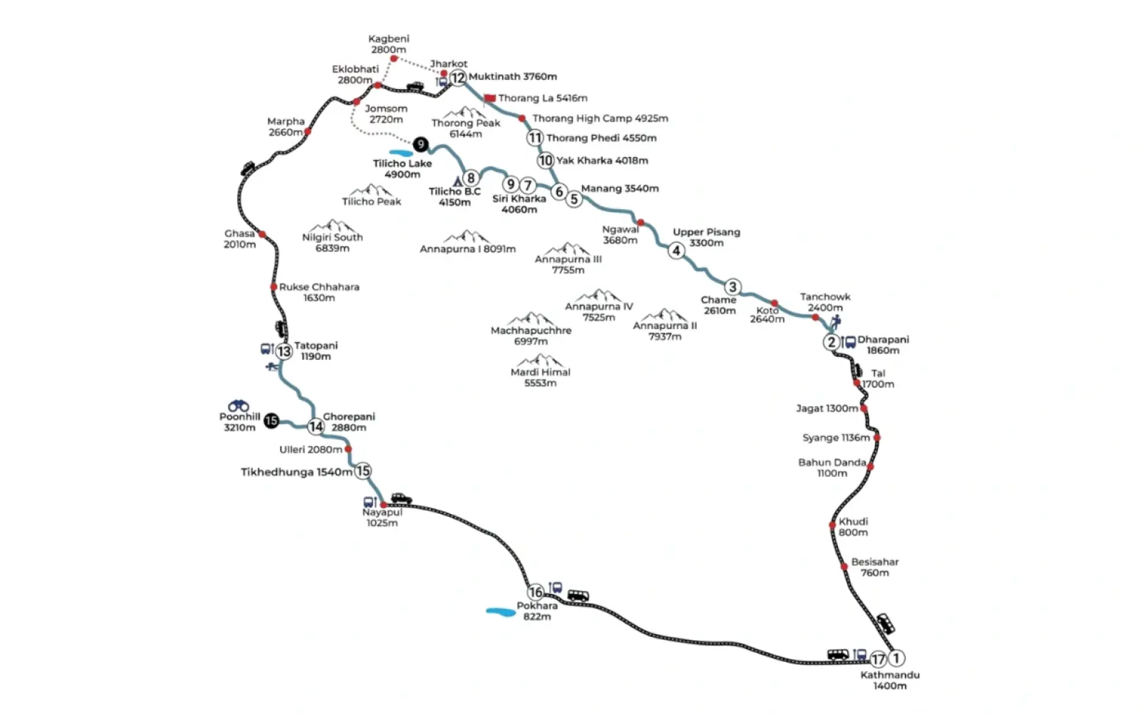
The Annapurna Circuit route map traces a near-complete loop around the Annapurna Massif in northwestern Nepal — one of the most geographically diverse treks in the Himalayas. The classic route runs from Jagat(1300m) in the east, winds through the Marshyangdi River valley, climbs dramatically through Manang, crosses the notorious Thorong La Pass (5,416m), then descends through the sacred pilgrimage town of Muktinath into the arid rain-shadow landscape of Mustang, finishing in Jomsom or continuing south to Nayapul.
The trail takes between 14 and 21 days for most trekkers. The map of the Annapurna Circuit trek nepal shows two very different worlds: the lush, forested, Hindu and Buddhist east, and the dry, high-altitude Tibetan plateau culture of the west. That dramatic contrast is precisely why this remains one of the world's great treks.
The standard direction is counterclockwise — east to west — because crossing Thorong La from Manang to Muktinath is significantly safer and less strenuous than the reverse. Nearly all guides, including ours, strongly recommend this direction.
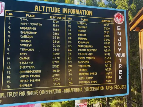
One of the most common questions we get is: "How long is the Annapurna Circuit, really?" The annapurna circuit trek map with distance shows a total walking distance of roughly 160–230 km, depending on where you start and finish, and whether you include side trips like Tilicho Lake or Ice Lake. Below is a realistic, section-by-section breakdown used by our guide team.
| Day | Route Section | Distance | Est. Hours | Altitude |
|---|---|---|---|---|
| Day 1 | Jagat → Dharapani | ~15 km | 5–6 hrs | 1,960m |
| Day 2 | Dharapani → Chame | ~16 km | 5–6 hrs | 2,710m |
| Day 3 | Chame → Pisang | ~17 km | 5–6 hrs | 3,300m |
| Day 4 | Pisang → Manang | ~22 km | 6–8 hrs | 3,519m |
| Day 5 | Manang (Acclimatization) | Local hike | Rest / short hike | 3,519m |
| Day 6 | Manang → Yak Kharka | ~10 km | 3–4 hrs | 4,018m |
| Day 7 | Yak Kharka → Thorong Phedi | ~8 km | 2–3 hrs | 4,450m |
| Day 8 | Thorong Phedi → Thorong La Pass → Muktinath | ~18 km | 7–9 hrs | 5,416m |
| Day 9 | Muktinath → Jomsom | ~19 km | 5–6 hrs | 2,720m |
| Days 10+ | Jomsom → Nayapul (via Tatopani) | ~80 km | 3–4 days | 1,070m |
💡 Local Insight: Many trekkers now take a jeep or bus from Besisahar to Chame (or even Dharapani) to skip the lower, road-dominated section. This shortens the trek by 2–3 days but misses some beautiful forest sections. Ask our team which start point makes sense for your schedule.
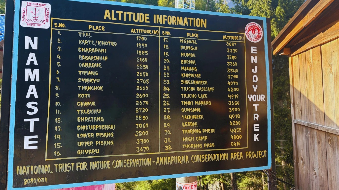
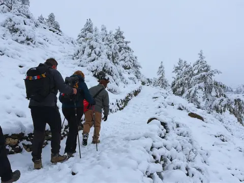
The Annapurna Circuit trek elevation map is arguably the most important planning tool for this trek. The altitude gain is dramatic, relentless, and non-negotiable — you'll climb from just 1300 metres at Jgat to 5,416 metres at Thorong La Pass, the highest point on the circuit and one of the highest trekking passes in the world.
⚠️ Altitude Warning — AMS Risk Zones: Acute Mountain Sickness (AMS) is a serious concern above 3,000m. The most dangerous stretch is the final push from Thorong Phedi (4,450m) to Thorong La (5,416m) — a 1,000m gain in a single morning. Trekkers who rush acclimatization in Manang put themselves at real risk. Symptoms include headache, nausea, and loss of coordination. Descend immediately if symptoms worsen. We always carry emergency oxygen on guided treks.
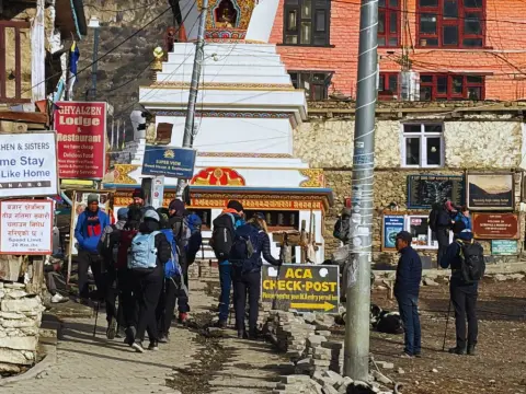
The annapurna circuit map with villages is where the trek really comes alive. Each settlement on this route has its own character, culture, and practical importance for your itinerary. Here's our guide team's ground-level description of every major stop on the annapurna circuit trek trail map.
The practical modern start of the Annapurna Circuit. A stone-paved village along the Marsyangdi River where most trekkers begin after driving from Besisahar. Permit checkpoints are here, and from this point onward, the trail feels like a true Himalayan trek rather than a road walk.
A key junction where the Annapurna Circuit meets the Manaslu Circuit trail. The village has a lively trekking atmosphere with good lodges and bakeries. From here, the vegetation begins to change, and you start feeling the transition toward alpine terrain.
Administrative center of Manang District. Has a bank, internet, good lodges, and the famous Chame hot springs nearby. The trail starts narrowing into the gorge here and the landscape dramatically transforms.
A classic Tibetan-style village perched above the valley with one of the most photogenic monasteries on the entire circuit. Always choose Upper Pisang over Lower for the views — the extra 30-minute climb is worth every step.
The social heart of the upper circuit. Spend at least two nights here. The Himalayan Rescue Association holds free daily altitude talks that every trekker should attend. Ice Lake day hike (4,600m) is essential for acclimatization.
A small yak-herding settlement above the tree line. The landscape turns stark and beautiful here. Basic accommodation; the high altitude makes this feel genuinely remote.
The final lodge before Thorong La. You can sleep here or at High Camp (4,850m). Most trekkers start the pass crossing by 4–5 AM from here. Facilities are basic but sufficient.
A revered Hindu and Buddhist pilgrimage site with a famous flame-and-water temple. After the brutal pass crossing, arriving here feels like salvation — in every sense. Excellent lodges and hot showers available.
The administrative center of the Lower Mustang region. Has an airport with daily flights to Pokhara — a popular exit option. Known for apples, local buckwheat dishes, and intense afternoon winds.
A common question from trekkers planning via the annapurna circuit trek google maps route is: "Can I just use Google Maps for navigation on the trail?" The short answer is: partly, but not reliably enough to depend on alone.
💡 Our Navigation Recommendation: Maps.me with the Nepal offline map pre-downloaded is excellent and free. Gaia GPS is the professional choice with detailed topo layers. Always carry a printed backup of the annapurna circuit trek trail map — we provide this to all guided trekkers before departure. The Himalayan Map House 1:100,000 Annapurna sheet is the gold standard printed map.
The annapurna circuit map with tilicho lake route adds one of the trek's most spectacular detours — a high-altitude lake sitting at a jaw-dropping 4,919 metres, making it one of the highest lakes in the world. The Tilicho Lake extension is firmly on the must-do list for trekkers who have the fitness and the time.
The detour branches off at Shree Kharka (also called Khangsar), approximately 2 hours before reaching Manang on the main trail. From there, it's a full day hike to Tilicho Base Camp (4,150m), where you overnight, then summit to the lake shore the following morning (3–4 hours one-way). You then backtrack to the main circuit and continue toward Yak Kharka.
The Tilicho detour adds roughly 2 extra days to your circuit. The trail above Tilicho Base Camp is exposed and involves some rocky scrambling — there have been accidents from rockfall on the steep hillside section. Our guides always lead this section carefully and check trail conditions before departure.
⚠️ Who Should Take the Tilicho Route? Tilicho Lake is best suited for trekkers with good physical fitness, no serious acclimatization issues, and at least 18–20 days total. If you're on a tight schedule or feeling altitude effects in Manang, skip Tilicho and focus on crossing Thorong La safely. There's no shame in making the smart call — the main circuit is extraordinary on its own.
The annapurna circuit and base camp trek map represents one of the great extended Himalayan adventures — combining the circuit loop with a detour to Annapurna Base Camp (ABC, 4,130m), the iconic bowl surrounded by Annapurna I, Machhapuchhre, and Hiunchuli.
There are two main ways to combine these routes. The most popular approach is to complete the full Annapurna Circuit, descend to Tatopani or Nayapul, and then add the ABC trek via Ghorepani-Poon Hill. This makes for a 24–28 day mega-trek and is offered as a packaged itinerary by Majestic Trails Nepal.
The second approach — trickier to route — involves dropping into the Modi Khola valley from the western side of the circuit before Jomsom. This is less common and requires an experienced guide to navigate correctly, but gives an incredibly raw, less-touristed experience.
We've prepared a detailed, print-ready annapurna circuit trek map pdf that you can download before your trip. The map includes the full route from jagat to Jomsom/Nayapul, altitude markers for all major villages, the Tilicho Lake detour, the Thorong La Pass crossing area with waypoints, and emergency contact numbers for the Himalayan Rescue Association.
⬇ Contact us for Free Annapurna Circuit Trek Printable Map — PDF (Full route, villages, elevation, Thorong La detail, and Tilicho Lake side trip. Print at A3 for best results. Updated for 2026 trail conditions.)
We also recommend carrying the Himalayan Map House "Around Annapurna" sheet (1:100,000 scale) as a physical backup — available at bookshops in Kathmandu's Thamel district and at our office.
This is one of the most important questions we answer for first-time trekkers. The annapurna circuit trek map for beginners looks manageable on paper, but the reality on the ground requires honest assessment. Here's our truthful take after years of guiding people of all fitness levels.
There's no technical climbing involved. You don't need ropes, crampons, or prior mountaineering experience. The trail is well-marked and teahouses are spaced every few hours on most sections. In that sense, yes, a fit beginner can complete the Annapurna Circuit.
💡 Our Honest Advice for First-Timers: If this is your first trekking trip, trek with a guide. Not because the trail is impossible to navigate alone, but because a knowledgeable local guide will manage your acclimatization schedule, recognize early AMS symptoms, know which teahouses are trustworthy, and handle any emergencies. The cost is minor compared to the value — and the experience is genuinely richer. Start training with day hikes of 15–20 km at elevation 3–4 months before your trip.
Our senior guides — men like Pasang Sherpa and Ram Gurung, who've crossed Thorong La over 80 times combined — share the practical wisdom you won't find in generic travel blogs.
Leave Thorong Phedi or High Camp no later than 5:00 AM. The pass typically clears of cloud by mid-morning, but violent afternoon winds can arrive by noon, especially in spring and autumn. We once had to turn a group back at 5,200m because of winds that literally pushed people sideways. The mountain doesn't care about your itinerary.
The mandatory rest day in Manang isn't a rest day — it's an active acclimatization day. Hike up to the viewpoint above the village (4,200m+), visit Gangapurna Lake, or do the Ice Lake hike (4,600m). The golden rule: climb high, sleep low. Sitting in a teahouse eating dal bhat all day achieves very little physiologically.
October–November is the gold standard — stable skies, excellent visibility, busy trails. March–April offers rhododendron forests at lower elevations and fewer crowds, but the pass can have more fresh snow. Avoid June–September (monsoon): the trail becomes dangerously slippery, leeches appear below 2,500m, and mountain views are largely obscured for weeks.
One item beginners consistently underpack: warm layers for evenings. Even in October, temperatures in Manang and above drop below freezing at night. Teahouse blankets exist but aren't always clean or warm enough. A good down jacket and sleeping bag liner are non-negotiables above 3,500m.
The main Annapurna Circuit trail is well-marked with cairns, painted arrows, and signboards in most sections. The section most likely to confuse trekkers is the Upper vs Lower Pisang fork and the approach to Tilicho Base Camp. If in doubt, ask a local — every teahouse owner on this trail knows the route better than any app.
The Annapurna Circuit Trek map is more than lines on paper — it's a blueprint for one of the most transformative mountain experiences on the planet. From the subtropical lowlands of jagat to the wind-scoured heights of Thorong La Pass, the Marshyangdi valley to the Mustang plateau, this route takes you through a dizzying range of landscapes, cultures, and altitudes within a single journey.
Understanding your route — the distances, the altitude stages, the village stops, the side trips — is the difference between a stressful scramble and a confident, joyful adventure. We hope this guide gives you exactly that foundation.
At Majestic Trails Nepal, we've been walking this circuit since before the teahouses had solar panels. We know where to turn left when the trail splits, which lodges have the best dal bhat above 4,000m, and when to push and when to rest. If you'd like that knowledge walking beside you, we'd be honoured to be your guide team.
Book Your Trek with Majestic Trails Nepal → Get a Free Custom Itinerary →
The Annapurna Circuit trek is approximately 160–230 km in total distance, depending on your start and finish points and whether you include side trips like Tilicho Lake or the southern section to Nayapul. The core route from jagat to Jomsom is around 140–160 km. Most trekkers complete it in 14–21 days.
The highest point is Thorong La Pass at 5,416 metres (17,769 feet). This is one of the highest trekking passes in the world and is the defining challenge of the Annapurna Circuit. A fit, well-acclimatized trekker can cross it without technical climbing equipment, but it demands serious preparation and respect for altitude sickness risks.
Yes — Majestic Trails Nepal offers a free downloadable Annapurna Circuit trek map PDF through the link in this guide. It includes the full route from jagat to Jomsom, village altitude markers, the Tilicho Lake detour, and emergency contact numbers. We recommend printing it at A3 size for trail use. The Himalayan Map House also sells an excellent 1:100,000 printed sheet map in Kathmandu's Thamel area.
No — they are two distinct treks. The Annapurna Circuit is a loop around the entire Annapurna Massif (160–230 km, 14–21 days), crossing Thorong La Pass at 5,416m. The Annapurna Base Camp (ABC) trek is a shorter out-and-back route from Nayapul to the base camp at 4,130m (typically 7–12 days). They can be combined into a 24–28 day extended itinerary — contact us for details.
You need two permits: the Annapurna Conservation Area Permit (ACAP). Both can be obtained in Kathmandu (at the Tourism Board office in Bhrikutimandap) or Pokhara. As of 2026, ACAP costs NPR 3,000 (~$22 USD) for individual trekkers. If you trek with a registered agency like Majestic Trails Nepal, we handle all permits as part of your package.
The Annapurna Circuit Trek is one of the world’s most legendary long-distance treks — a journey that circles the Annapurna massif through Nepal’s most...
The Annapurna Circuit requires only one permit in 2026: the Annapurna Conservation Area Permit (ACAP). It costs NPR 3,000 for foreign nationals and NP...
The Annapurna Circuit Trek altitude is both the greatest challenge and the most rewarding aspect of this legendary Himalayan journey. As a trekking co...
At Majestic Trails Nepal, we've guided hundreds of trekkers across the Annapurna Circuit. One question we hear constantly: "How difficult is the Annap...
