[{"name":"Langtang Valley Trek","duration":"10","image_url":"https:\/\/www.majestictrailsnepal.com\/storage\/trip-galleries\/1\/thumb_e7907ed736676d12e6ab17328008e746.webp","offer_price":null,"url":"https:\/\/www.majestictrailsnepal.com\/trips\/langtang-valley-trek"},{"name":"Everest Base Camp Trek","duration":"14","image_url":"https:\/\/www.majestictrailsnepal.com\/storage\/trip-galleries\/2\/thumb_2ebcee400f90dce9ebae50336baef19f.webp","offer_price":null,"url":"https:\/\/www.majestictrailsnepal.com\/trips\/everest-base-camp-trek"},{"name":"Everest Panorama Trek","duration":"9","image_url":"https:\/\/www.majestictrailsnepal.com\/storage\/trip-galleries\/3\/thumb_6da276d9bc519f19f942bac67d07768e.webp","offer_price":950,"url":"https:\/\/www.majestictrailsnepal.com\/trips\/everest-panorama-trek"},{"name":"Annapurna Base Camp Trek","duration":"14","image_url":"https:\/\/www.majestictrailsnepal.com\/storage\/trip-galleries\/4\/thumb_980cdfac9661a1147b5288be788ba0e9.webp","offer_price":null,"url":"https:\/\/www.majestictrailsnepal.com\/trips\/annapurna-base-camp-trek"},{"name":"Annapurna Base Camp Express Trek","duration":"9","image_url":"https:\/\/www.majestictrailsnepal.com\/storage\/trip-galleries\/5\/thumb_ba8e1f22a8d0c9745785ce4fc2d23407.webp","offer_price":null,"url":"https:\/\/www.majestictrailsnepal.com\/trips\/annapurna-base-camp-express-trek"},{"name":"Annapurna Circuit Trek","duration":"15","image_url":"https:\/\/www.majestictrailsnepal.com\/storage\/trip-galleries\/6\/thumb_cc65a3e2dbf21addf875c5087178f6bf.webp","offer_price":null,"url":"https:\/\/www.majestictrailsnepal.com\/trips\/annapurna-circuit-trek"},{"name":"Ghorepani Poon Hill Trek","duration":"8","image_url":"https:\/\/www.majestictrailsnepal.com\/storage\/trip-galleries\/7\/thumb_aeda9e6388ab2692138cc9c9efa81a7f.webp","offer_price":null,"url":"https:\/\/www.majestictrailsnepal.com\/trips\/ghorepani-poon-hill-trek"},{"name":"Mardi Himal Trek","duration":"9","image_url":"https:\/\/www.majestictrailsnepal.com\/storage\/trip-galleries\/8\/thumb_c511ee87ecab8ff015210dd647392d66.webp","offer_price":null,"url":"https:\/\/www.majestictrailsnepal.com\/trips\/mardi-himal-trek"},{"name":"Manaslu Circuit Trek","duration":"15","image_url":"https:\/\/www.majestictrailsnepal.com\/storage\/trip-galleries\/9\/thumb_97557159d4e271d17336ddc334e95dd7.webp","offer_price":null,"url":"https:\/\/www.majestictrailsnepal.com\/trips\/manaslu-circuit-trek"},{"name":"Upper Mustang Trek","duration":"16","image_url":"https:\/\/www.majestictrailsnepal.com\/storage\/trip-galleries\/10\/thumb_6a9b52ecd1d8cda92d594e5351431d6e.webp","offer_price":null,"url":"https:\/\/www.majestictrailsnepal.com\/trips\/upper-mustang-trek"},{"name":"Pokhara City Tour","duration":"1","image_url":"https:\/\/www.majestictrailsnepal.com\/storage\/trip-galleries\/11\/thumb_cf762ba4c20363bd1c0f239db35fcc84.webp","offer_price":null,"url":"https:\/\/www.majestictrailsnepal.com\/trips\/pokhara-city-tour"},{"name":"Paragliding in Pokhara","duration":"1","image_url":"https:\/\/www.majestictrailsnepal.com\/storage\/trip-galleries\/12\/thumb_b896201edf88bbe0f570e876c3c337a3.webp","offer_price":70,"url":"https:\/\/www.majestictrailsnepal.com\/trips\/paragliding-in-pokhara"},{"name":"Kathmandu City Tour","duration":"2","image_url":"https:\/\/www.majestictrailsnepal.com\/storage\/trip-galleries\/13\/thumb_846ad05bd3ce7bebb3843c24c08db6f9.webp","offer_price":null,"url":"https:\/\/www.majestictrailsnepal.com\/trips\/kathmandu-city-tour"},{"name":"Lumbini Buddhist Pilgrimage Tour","duration":"4","image_url":"https:\/\/www.majestictrailsnepal.com\/storage\/trip-galleries\/14\/a2998dca0ce22f28a61c3862dd47f6a3.webp","offer_price":null,"url":"https:\/\/www.majestictrailsnepal.com\/trips\/lumbini-buddhist-pilgrimage-tour"},{"name":"5 days langtang valley trek","duration":"5","image_url":"https:\/\/www.majestictrailsnepal.com\/storage\/trip-galleries\/15\/thumb_7a6c65c139b8085d220ac01913cb1448.webp","offer_price":510,"url":"https:\/\/www.majestictrailsnepal.com\/trips\/5-days-langtang-valley-trek"},{"name":"Leisure Port Nepal Price: Rafting and Camping Adventure","duration":"7","image_url":"https:\/\/www.majestictrailsnepal.com\/storage\/trip-galleries\/17\/thumb_02cb8c3f0697c7c5c4f73d744b47d87f.webp","offer_price":550,"url":"https:\/\/www.majestictrailsnepal.com\/trips\/leisure-port-nepal-price-rafting-and-camping-adventure"},{"name":"10 days spiritual tour in Nepal","duration":"10","image_url":"https:\/\/www.majestictrailsnepal.com\/storage\/trip-galleries\/18\/thumb_b4e7eba000673d1bce6b56abb422fe3b.webp","offer_price":1200,"url":"https:\/\/www.majestictrailsnepal.com\/trips\/10-days-spiritual-tour-in-nepal"},{"name":"Annapurna Circuit Short Trek","duration":"10","image_url":"https:\/\/www.majestictrailsnepal.com\/storage\/trip-galleries\/19\/thumb_7bae8a91d77fdd1e9141dcf5f72995f4.webp","offer_price":null,"url":"https:\/\/www.majestictrailsnepal.com\/trips\/annapurna-circuit-short-trek"},{"name":"Best Short Manaslu Circuit Trek","duration":"11","image_url":"https:\/\/www.majestictrailsnepal.com\/storage\/trip-galleries\/20\/thumb_ac1b4977a3fce9d11ee68240cad675b6.webp","offer_price":null,"url":"https:\/\/www.majestictrailsnepal.com\/trips\/best-short-manaslu-circuit-trek"},{"name":"Langtang Gosaikunda Trek","duration":"13","image_url":"https:\/\/www.majestictrailsnepal.com\/storage\/trip-galleries\/22\/thumb_577a6402f2ca4b3f12bfd80b96b33a23.webp","offer_price":940,"url":"https:\/\/www.majestictrailsnepal.com\/trips\/langtang-gosaikunda-trek"},{"name":"3 Passes Trek Nepal","duration":"22","image_url":"https:\/\/www.majestictrailsnepal.com\/storage\/trip-galleries\/24\/thumb_8020edea67aefce87e9012dc89a60087.webp","offer_price":null,"url":"https:\/\/www.majestictrailsnepal.com\/trips\/3-passes-trek-nepal"},{"name":"Tsum Valley Trek","duration":"13","image_url":"https:\/\/www.majestictrailsnepal.com\/storage\/trip-galleries\/25\/thumb_194c03e3c3463dff07a3f621a81ef9ea.webp","offer_price":null,"url":"https:\/\/www.majestictrailsnepal.com\/trips\/tsum-valley-trek"},{"name":"Gokyo and Renjo La Pass Trek","duration":"14","image_url":"https:\/\/www.majestictrailsnepal.com\/storage\/trip-galleries\/26\/thumb_7b865f0f0d0d4c6807b625b6e391b56d.webp","offer_price":1490,"url":"https:\/\/www.majestictrailsnepal.com\/trips\/gokyo-and-renjo-la-pass-trek"},{"name":"Honeymoon Tour in Nepal","duration":"9","image_url":"https:\/\/www.majestictrailsnepal.com\/storage\/trip-galleries\/27\/thumb_dabf449c090bb16efd5823c653eb61b3.webp","offer_price":null,"url":"https:\/\/www.majestictrailsnepal.com\/trips\/honeymoon-tour-in-nepal"},{"name":"Pikey Peak Trek","duration":"10","image_url":"https:\/\/www.majestictrailsnepal.com\/storage\/trip-galleries\/28\/thumb_5425e57ce3ea84d31a7b24b83b1af94f.webp","offer_price":1090,"url":"https:\/\/www.majestictrailsnepal.com\/trips\/pikey-peak-trek"},{"name":"Makalu Base Camp Trek","duration":"17","image_url":"https:\/\/www.majestictrailsnepal.com\/storage\/trip-galleries\/29\/thumb_d68c8ec6492540c922045d825a38cd50.webp","offer_price":null,"url":"https:\/\/www.majestictrailsnepal.com\/trips\/makalu-base-camp-trek"},{"name":"Nepal Winter Tour","duration":"8","image_url":"https:\/\/www.majestictrailsnepal.com\/storage\/trip-galleries\/30\/thumb_c8491c0c4b1fb19d8e93630866895799.webp","offer_price":null,"url":"https:\/\/www.majestictrailsnepal.com\/trips\/nepal-winter-tour"},{"name":"Maratika Tour in Nepal","duration":"6","image_url":"https:\/\/www.majestictrailsnepal.com\/storage\/trip-galleries\/31\/thumb_97948560c5a12a486f9ac2b76567cafd.webp","offer_price":null,"url":"https:\/\/www.majestictrailsnepal.com\/trips\/maratika-tour-in-nepal"},{"name":"Nepal Lake Trek","duration":"14","image_url":"https:\/\/www.majestictrailsnepal.com\/storage\/trip-galleries\/32\/thumb_d9b260fe13127816f5b3c25447caf70c.webp","offer_price":null,"url":"https:\/\/www.majestictrailsnepal.com\/trips\/nepal-lake-trek"},{"name":"Taste of Nepal Tour Package","duration":"9","image_url":"https:\/\/www.majestictrailsnepal.com\/storage\/trip-galleries\/33\/thumb_f4b55ab5760a8e057b4c3e208e25ab36.webp","offer_price":null,"url":"https:\/\/www.majestictrailsnepal.com\/trips\/taste-of-nepal-tour-package"},{"name":"Poon Hill Yoga Trek in Nepal","duration":"9","image_url":"https:\/\/www.majestictrailsnepal.com\/storage\/trip-galleries\/34\/thumb_904b238e690107c5c9b1092296880cc9.webp","offer_price":null,"url":"https:\/\/www.majestictrailsnepal.com\/trips\/poon-hill-yoga-trek-in-nepal"},{"name":"Nar Phu Nepal Trek","duration":"10","image_url":"https:\/\/www.majestictrailsnepal.com\/storage\/trip-galleries\/35\/thumb_f959e3e22c260629add0ba61a4038812.webp","offer_price":null,"url":"https:\/\/www.majestictrailsnepal.com\/trips\/nar-phu-nepal-trek"},{"name":"Annapurna Base Camp Helicopter Tour","duration":"1","image_url":"https:\/\/www.majestictrailsnepal.com\/storage\/trip-galleries\/36\/thumb_e81861e8772a9d7fac92ab4a7d43e3bf.webp","offer_price":null,"url":"https:\/\/www.majestictrailsnepal.com\/trips\/annapurna-base-camp-helicopter-tour"}]
Does Mount Everest Belong to Nepal or China? The Complete 2026 Answer
Mount Everest belongs to both Nepal and China, as the international boundary line runs directly across its summit point. The southern slope of the mountain is located in Nepal's Solukhumbu District, where it is known as Sagarmatha and protected within Sagarmatha National Park. The northern slope lies in Tingri County within China's Tibet Autonomous Region, where it is called Chomolungma. Following a formal border treaty signed in 1961, both nations share ownership of the mountain and jointly manage its administration, which includes issuing separate climbing permits for their respective sides and mutually agreeing on its official height of 8,848.86 meters.
That answer sounds simple. But the story behind it spans diplomatic crises, a personal conversation between Mao Zedong and Nepal's prime minister, decades of contested height measurements, and a 2020 joint announcement that finally settled a four-meter disagreement between two nations. There's a lot more here than most sources bother to explain.
By the end of this guide, you'll know exactly where Everest sits on the map, how Nepal and China divided the world's highest peak, what the 2026 climbing permit rules look like on both sides, why Nepal still dominates the global Everest story despite shared legal ownership, and how you can experience the Everest region yourself without spending USD 15,000 on a summit permit.
Quick answer for searchers in a hurry:
Mount Everest is located on the border between Nepal and China. The summit sits exactly on the international boundary, with the southern face in Nepal's Solukhumbu District and the northern face in Tibet's Dingri County. Both countries share legal ownership under a 1960 border treaty, making Everest a binational peak at 8,848.86 meters (29,031.7 feet).
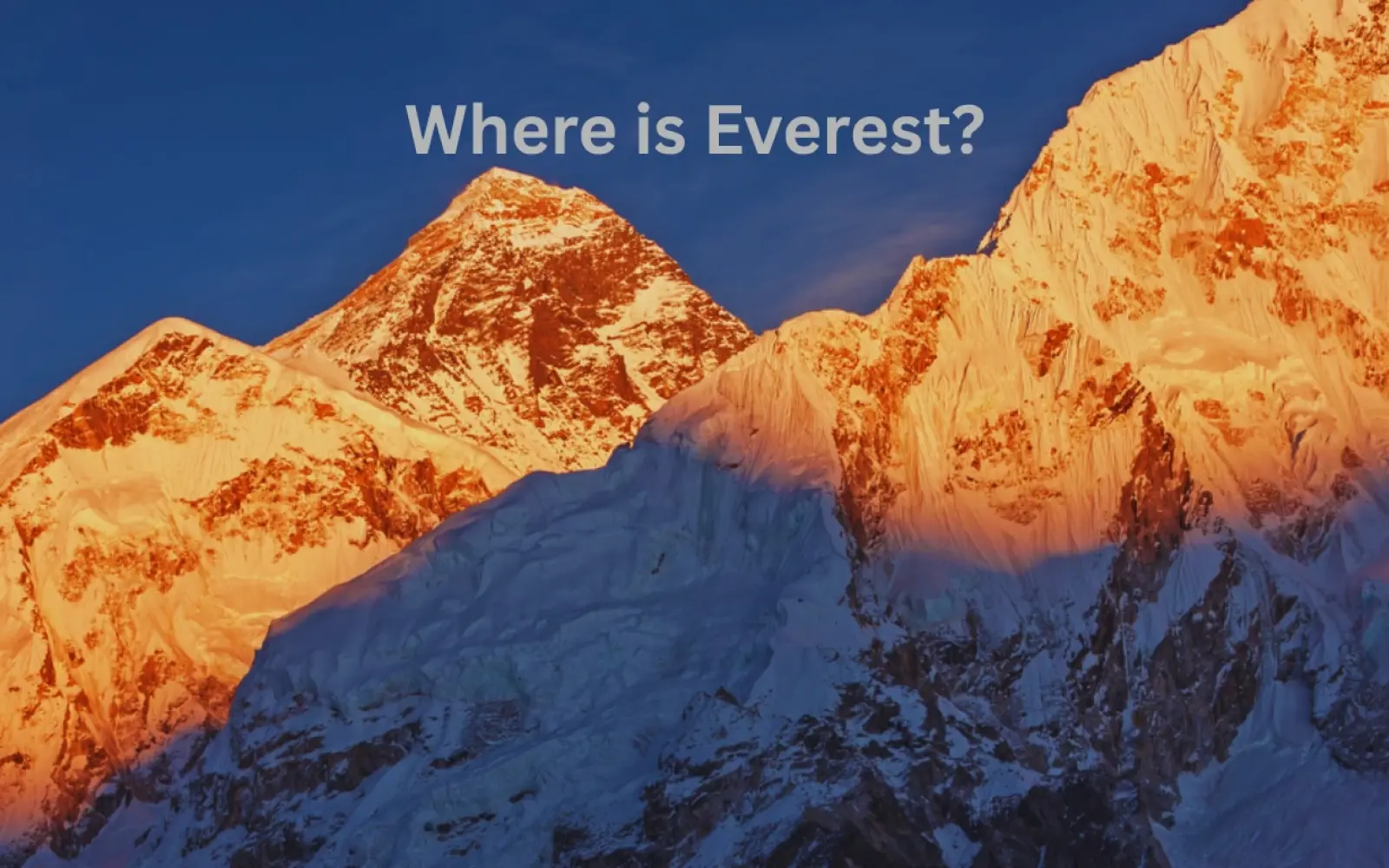
Where Is Mount Everest Located?
Where is Everest?
Mount Everest stands on the border between Nepal and China, in the Mahalangur Himal sub-range of the Himalayas. The summit itself sits precisely on the international boundary line. The southern slopes fall within Nepal's Solukhumbu District, Province No. 1, inside the protected area of Sagarmatha National Park. The northern slopes descend into Dingri (Tingri) County, Shigatse Prefecture, Tibet Autonomous Region.
More specifically, the Nepal side sits within Khumbu Pasanglhamu Rural Municipality, the administrative unit that covers the Khumbu valley and its high-altitude settlements, including the village of Namche Bazaar and the gateway town of Lukla. The China side falls under the administrative jurisdiction of the Tibet Autonomous Region, governed separately from mainland China with its own permit and travel restriction framework.
So what continent is Mount Everest in? Asia, specifically the South Asian Himalayan range that stretches across Nepal, China, India, Bhutan, and Pakistan. And what mountain range is Mount Everest in? The Himalayas, more specifically the Mahalangur Himal, a sub-range that includes several of the world's highest peaks including Lhotse (8,516 m), Makalu (8,485 m), and Cho Oyu (8,188 m).
When people ask where Mount Everest is located on a map, the answer places it at approximately 27.9881 degrees N latitude and 86.9250 degrees E longitude, on the Nepal-China border roughly 130 kilometers northeast of Kathmandu as the crow flies.
Does Nepal or China Own Mount Everest?
Who own the Everest Nepal or China?
Both countries own it. The summit is the border. That's not a political compromise or an unresolved gray area. It's a settled, treaty-based reality that has been in place since 1960.
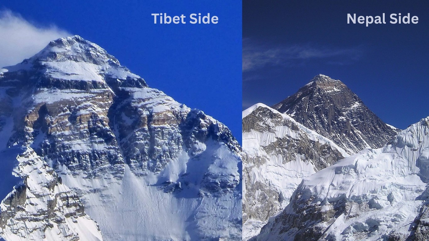
The summit ridge runs roughly east-west along the international boundary for approximately three kilometers, with the highest point on Earth sitting directly on the dividing line. Nepal administers the southern face through the Department of Tourism and Sagarmatha National Park. China administers the northern face through the China Tibet Mountaineering Association (CTMA) and the Tibet Autonomous Region government.
Here's what each country actually controls:
Feature
Nepal (South)
China / Tibet (North)
Official Name
Sagarmatha
Chomolungma / Qomolangma
Base Camp Location
Khumbu Glacier, 5,364 m
Rongbuk Valley, 5,150 m
Primary Route
South Col / Southeast Ridge
North Col / Northeast Ridge
Permit Issuing Body
Department of Tourism, Nepal
China Tibet Mountaineering Association
Trekker Access
Open, via Lukla flights
Restricted, multiple permits required
Annual Foreign Climbing Permits
300 to 517 (2025 data)
Significantly fewer
The mountain is a landmark of both countries, not one. Anyone who tells you Everest "belongs" to Nepal alone or China alone is giving you an incomplete answer. The legal position has been unambiguous for over six decades.
How the Border Was Decided: The History Behind the Treaty
This wasn't always settled. Before 1960, the Everest border was genuinely contested, and the debate reached the highest levels of both governments.
Before Diplomatic Relations
When Edmund Hillary and Tenzing Norgay made the first recorded summit on May 29, 1953, Nepal and China didn't yet have formal diplomatic ties. Those weren't established until August 1, 1955. Before that date, there was no official framework for discussing where one country ended and the other began on a shared mountain range.
The border question became urgent as both countries began asserting their relationship to the highest peak on Earth. For China, which had absorbed Tibet in 1950, the northern face of Everest fell under its newly extended jurisdiction. For Nepal, which had opened to foreign visitors in 1950, the southern face was rapidly becoming the gateway to the world's most famous summit.
The Mao-Koirala Exchange
When Nepal's first democratically elected Prime Minister BP Koirala visited China in 1960, the Everest question came to a head. Chinese Premier Zhou Enlai's position appeared to claim the full mountain, which Koirala immediately pushed back on, stating publicly that Nepal had staked its claim and the matter needed resolution through the joint border committee.
Mao Zedong himself got involved. In recorded exchanges from that period, Mao acknowledged that both sides felt emotional ownership of the peak. His actual words, roughly translated: "If all of it is given to you, sentimentally we shall feel sorry. If all of it is given to us, sentimentally you will feel sorry. We can have a boundary marker on top of it."
That is more or less what happened. The two sides agreed the summit would serve as the exact border point.
The 1960 Treaty
The Nepal-China Boundary Agreement of 1960 formally demarcated the border through the Himalayan range. The boundary runs from the western tripoint near Tinkar Pass southeastward across various Himalayan crests, passing through both Mount Everest and Mount Makalu before terminating at the eastern tripoint on Jongsong Peak. Everest was designated as the most prominent boundary marker on Earth.
That treaty remains in force. As of 2026, neither country has sought to revise it, and there is no active sovereignty dispute over the mountain.
Sagarmatha vs Chomolungma: Two Names, One Mountain
The name "Everest" is the youngest of the mountain's three identities. And honestly, it's the least meaningful of the three.
Nepal: Sagarmatha
Nepal calls the mountain Sagarmatha, a Sanskrit-derived name that translates roughly as "forehead of the sky" or "goddess of the sky." The Nepali government formally adopted this name in 1956, three years after the first Western-recognized summit. The surrounding protected area, Sagarmatha National Park, was established in 1976 and designated a UNESCO World Heritage Site in 1979. For Nepalis, Sagarmatha isn't just a geographic feature. It's a national symbol woven into cultural identity, postage stamps, banknotes, and the country's sense of itself in the world.
China and Tibet: Chomolungma / Qomolangma
In Tibet, the mountain has been known as Qomolangma for centuries, meaning "Goddess Mother of the World." China adapted this Tibetan name to Zhumulangma in Mandarin. The reverence embedded in that name runs deep. For Tibetan Buddhist communities on the northern slopes, the mountain is a sacred entity, not just a physical landmark. That relationship predates any cartographic survey by hundreds of years.
The Name "Everest"
The name most of the world uses today was proposed by British Surveyor General Andrew Waugh in 1865 to honor his predecessor Sir George Everest, who led the Great Trigonometric Survey of India in the 19th century. Sir George Everest himself apparently objected to the naming, partly because his surname didn't translate well into Hindi. None of that stopped the name from sticking globally.
The point worth understanding here is that both Nepal and China had been naming, revering, and culturally relating to this mountain long before any Western surveyor measured it. The "Everest" name is essentially a colonial artifact. The names Sagarmatha and Chomolungma carry the real historical weight.
Mount Everest Height: Why Nepal and China Once Disagreed
Mount Everest is 8,848.86 meters (29,031.7 feet) tall. That's the official figure, jointly announced by Nepal and China in December 2020. But getting to that number took decades of scientific disagreement and genuine national tension.
The Four-Meter Gap
For years, Nepal recognized the elevation as 8,848 meters, based on a 1954 Indian survey that measured the height including the snow cap on the summit. China measured 8,844 meters, counting only the bare rock height beneath the snow layer. Four meters sounds trivial. On the world's highest mountain, with nationalist pride attached to the measurement, it was enough to sustain a technical and diplomatic debate for decades.
Nepal's position was that the snow is a permanent feature of the summit and should be counted. China's position was that only the rock height represented the true elevation. Neither side was being unreasonable on purely scientific terms. Both were also defending a number that carried symbolic weight.
The 2020 Joint Survey
The disagreement ended formally when Nepal and China commissioned a joint survey using modern GPS technology, gravimetric corrections, and satellite data. The new figure, 8,848.86 meters, was jointly announced in December 2020. The revised measurement also accounted for geological uplift, acknowledging that the Himalayas are still rising as the Indian tectonic plate pushes northward under the Eurasian plate at roughly 5 centimeters per year.
Both governments signed off on 8,848.86 meters. It was the clearest demonstration yet of the two countries cooperating over a mountain that sits squarely on their shared border.
Mount Everest Height in Context
Measurement
Value
Official height (2020 joint survey)
8,848.86 m / 29,031.7 ft
Height in kilometers
8.849 km
Previous Nepal measurement
8,848 m (1954 Indian survey)
Previous China measurement
8,844 m (rock height only)
Everest Base Camp height (Nepal side)
5,364 m / 17,598 ft
Everest Base Camp height (Tibet side)
5,150 m / 16,896 ft
Annual uplift rate
approximately 5 mm per year
Climbing Everest: Nepal Side vs Tibet Side in 2026
Most climbers come from Nepal. That's not an accident. Here's what actually separates the two routes, and why the Nepal side dominates commercial expeditions.
The Nepal (South) Route
The South Col / Southeast Ridge route was first pioneered by Edmund Hillary and Tenzing Norgay on May 29, 1953, and it remains the most popular path to the summit by a significant margin. The route passes through the notorious Khumbu Icefall above Base Camp, then climbs to Camp 1 at roughly 6,065 m, Camp 2 at 6,400 m, Camp 3 at 7,470 m, and Camp 4 at the South Col at approximately 7,950 m before the final summit push.
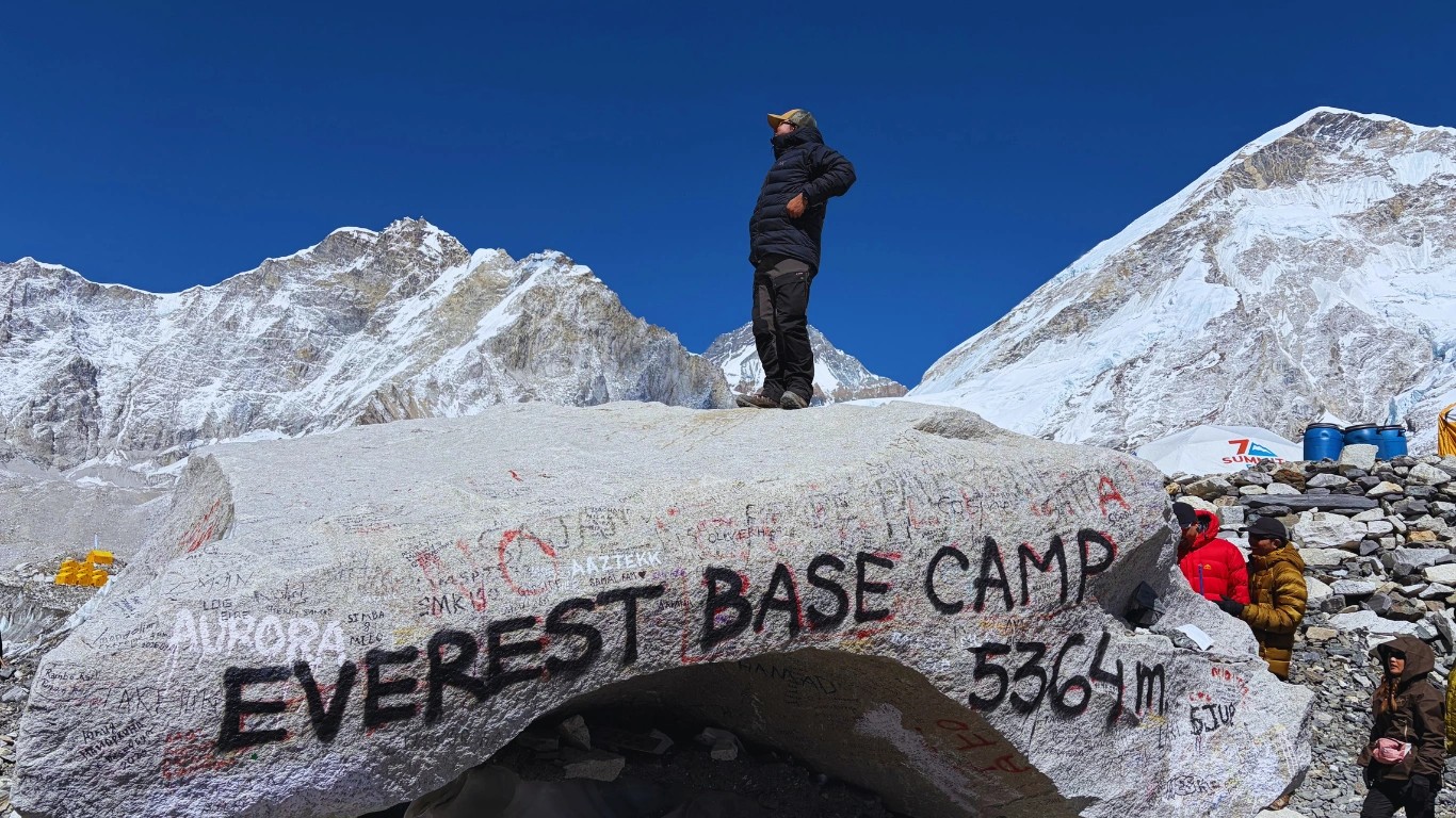
From the Nepal side, non-climbers can also reach Everest Base Camp at 5,364 meters without any technical climbing equipment. That's what makes the Everest region so accessible to the broader trekking world. You don't need climbing permits, technical gear, or prior mountaineering experience to stand at the foot of the world's highest peak.
2026 Permit Costs: Nepal (South Route)
Nepal implemented a 36% increase in Everest climbing permit fees effective September 1, 2025, the first major revision in nearly a decade.
Season
Old Fee
New Fee (from Sep 2025)
Spring (Mar to May)
USD 11,000
USD 15,000
Autumn (Sep to Nov)
USD 5,500
USD 7,500
Winter / Monsoon
USD 2,750
USD 3,750
For Nepali citizens, the spring permit fee doubled from NPR 75,000 to NPR 150,000.
New Rules in Effect for 2026
Nepal introduced several significant regulatory changes alongside the fee increase. Every two climbers on peaks above 8,000 meters must now be accompanied by one licensed, high-altitude trained guide. Climbers need to have previously summited at least one 7,000-meter peak within Nepal before they can apply for an Everest permit, a rule that took effect from Spring 2026. Permits are now valid for 55 days only, reduced from the previous 75-day window. Biodegradable waste bags are mandatory throughout the climb, and human waste must be carried back to Base Camp for proper disposal. Solo climbing and alpine-style expeditions are no longer permitted on the Nepal side.
These changes reflect Nepal's push to improve safety outcomes and reduce the overcrowding that generated global headlines in previous years.
The Tibet (North) Route
The North Col / Northeast Ridge route is longer in distance, more technically demanding in certain sections, and far less trafficked by commercial expeditions. The route passes through the North Col at 7,010 m before continuing up the northeast ridge to the summit. Several sections require fixed ropes and technical crampon work that the South Col route largely avoids in its lower reaches.
Access from Tibet is heavily restricted. Foreign climbers need a Tibet Travel Permit, a Tibet Alien Travel Permit, and a separate Frontier Permit for the Everest region. All three must be arranged through a licensed Chinese travel agency. Independent climbing is effectively impossible. China charges approximately USD 15,800 for a four-person group, with premium packages at USD 18,000 that include five-star accommodation in Lhasa and four-star facilities along the route to Base Camp. If a Nepali Sherpa is brought along, an additional work permit fee of roughly USD 4,500 per Sherpa applies on top of their salary.
Which Country Shares the Mount Everest Border?
Mount Everest's border is shared between Nepal and China (Tibet). The summit of Mount Everest sits exactly on the international border between these two countries, with the southern face in Nepal and the northern face in the Tibet Autonomous Region of China.
Quick facts about the Mount Everest border:
Country
Side of Everest
Region
Standard Climbing Route
Nepal
Southern face
Solukhumbu District, Province No. 1
South Col Route (most popular)
China (Tibet)
Northern face
Tibet Autonomous Region
North Col Route
Important context for the Mount Everest border question:
The border runs exactly across the summit at 8,848.86 m
Nepal controls the southern climbing approach and Sherpa cultural heart
China (Tibet) controls the northern climbing approach via the Friendship Highway
Approximately 90% of international climbers approach Everest from the Nepal side
The Everest Base Camp Trek in Nepal reaches 5,364 m on the southern side
China's Everest Base Camp on the northern side sits at approximately 5,150 m
Why Mount Everest is associated with Nepal more than China:
Despite the technical border position, Mount Everest is overwhelmingly associated with Nepal because the 1953 first ascent by Hillary and Tenzing Norgay was from the Nepal side, the Sherpa community that supports all climbing expeditions is Nepali, the iconic Everest Base Camp Trek goes entirely through Nepal, all major trekking infrastructure (Lukla, Namche Bazaar, Tengboche) is in Nepal, and Mount Everest's Nepali name "Sagarmatha" is more widely known than the Tibetan name "Chomolungma."
Short answer: Mount Everest sits on the border between Nepal and China (Tibet). The summit itself is exactly on this international border — making both countries the official border-sharing nations of the world's highest mountain.
Is Mount Everest Located in the Alps?
No, Mount Everest is not located in the Alps. Mount Everest is located in the Himalayas, a completely different mountain range on a different continent. The Alps are in Europe, while the Himalayas are in Asia. These are two separate mountain systems with no geographic connection.
The honest comparison — Alps vs Himalayas:
Feature
The Alps
The Himalayas
Continent
Europe
Asia
Countries
France, Switzerland, Italy, Austria, Germany, Slovenia, Liechtenstein, Monaco
Nepal, India, Bhutan, China (Tibet), Pakistan
Highest peak
Mont Blanc (4,808 m)
Mount Everest (8,848.86 m)
Mountain range length
~1,200 km
~2,400 km
Peaks above 8,000 m
0
10 (all in the Himalayas)
Age (geological)
~65 million years
~50 million years
Tectonic plates involved
African + Eurasian
Indian + Eurasian
Why people sometimes confuse Mount Everest with the Alps:
Both are major snow-capped mountain ranges with famous climbing history
Both are popular international tourism destinations
The English-language word "alpine" originally meant "Alps-like" but is now used for any high-altitude environment
Mountaineering terminology (alpine climbing, alpine style) originated in the Alps but applies globally
Where Mount Everest is actually located:
Mount Everest is in the Mahalangur range of the Himalayas, on the border between Nepal and China (Tibet). It is located approximately 4,000 km east of the Alps. To stand on top of Mount Everest, you would need to climb 4,040.86 m higher than the tallest peak in the Alps (Mont Blanc).
Short answer: No, Mount Everest is not located in the Alps. Mount Everest is in the Himalayas in Asia, while the Alps are a separate mountain range in Europe. The two are on different continents approximately 4,000 km apart.
Does Mount Everest Border Japan?
No, Mount Everest does not border Japan. Mount Everest is located on the border between Nepal and China (Tibet). Japan is a separate country approximately 4,500 km east of Mount Everest, located across the East China Sea and the Pacific Ocean.
Geographic facts that clear up the confusion:
Country
Borders Mount Everest?
Distance to Everest
Nepal
Yes — direct border
0 km (border runs across summit)
China (Tibet)
Yes — direct border
0 km (border runs across summit)
India
No (but nearby)
~150 km south of Everest
Bhutan
No
~600 km east of Everest
Pakistan
No
~1,400 km northwest of Everest
Japan
No
~4,500 km east of Everest
Why people might think Mount Everest borders Japan:
Both Nepal and Japan are in Asia, but they are far apart
Japanese climbers have a strong mountaineering tradition on Everest (Junko Tabei was the first woman to summit Everest in 1975)
Japanese tourists are among the most frequent visitors to Nepal for trekking
Mount Fuji in Japan is the most famous Japanese mountain — but it is only 3,776 m, far shorter than Mount Everest
The actual countries that border Mount Everest:
Mount Everest has only two border-sharing countries — Nepal on the southern face (which includes the standard climbing route and the Everest Base Camp Trek) and China (Tibet Autonomous Region) on the northern face (which includes the alternate climbing route via the North Col). No other country touches the Mount Everest border. Japan is in East Asia; Mount Everest is in South Asia.
Short answer: No, Mount Everest does not border Japan. Mount Everest is on the border between Nepal and China (Tibet). Japan is approximately 4,500 km east of Mount Everest, separated by China, the East China Sea, and the Pacific Ocean.
Nepal vs Tibet Route Comparison
Factor
Nepal (South)
Tibet / China (North)
Route
South Col / Southeast Ridge
North Col / Northeast Ridge
Permit Cost
USD 15,000 per person (spring)
USD 15,800 per group of four
Access
Open via Lukla flights
Restricted, multiple permits required
Trekking Infrastructure
Highly developed
Limited
Commercial Popularity
Very high
Low to moderate
Solo Climbing
Not permitted
Not permitted
Base Camp Elevation
5,364 m
5,150 m
The bottom line: Nepal's side is more open, better equipped, and attracts the vast majority of annual Everest expeditions. The Tibet route appeals to a smaller, often more experienced climbing demographic willing to navigate significantly more logistical complexity.
Why the World Associates Everest More with Nepal
Legally, the mountain belongs equally to both countries. So why does Nepal get most of the global credit? There are several honest reasons, and none of them are unfair to China.
First ascent history set the narrative. The 1953 Hillary-Norgay summit came from the Nepal side, and it captured global media attention at a time when Tibet was completely closed to Western climbers. The image of two men standing on the summit, approached from Kathmandu and the Khumbu valley, fixed the Nepal-Everest connection in the global imagination before any alternative narrative could form.
Tibet was closed for decades. China's absorption of Tibet in 1950 effectively shut the northern route to foreign climbers for a long period. Nepal, which opened to foreign visitors in 1950, became the only accessible gateway. By the time Tibet reopened to climbing expeditions, Nepal had built an unshakeable infrastructure and reputation around Everest that no amount of political repositioning could dislodge.
The Khumbu trekking infrastructure. The Everest Base Camp trek on Nepal's side is one of the most recognizable adventure routes on the planet. The Khumbu valley has a layered network of tea houses, lodges, medical posts, porter services, and a well-worn trail that has been built up over seven decades. There is no equivalent on the Tibet side in terms of accessible, affordable trekking infrastructure for non-climbers.
Sherpa identity. The Sherpa community, based entirely on Nepal's side in the Khumbu valley, has become globally synonymous with Everest. Kami Rita Sherpa holds the world record for most Everest summits. Tenzing Norgay became a cultural icon. Sherpa guides are integral to the commercial climbing industry. Their skills, culture, and sacrifice are inseparable from how the world understands this mountain.
Tourism revenue. Nepal's economy is deeply tied to the Everest region. The mountain attracts thousands of trekkers and climbers annually. Permit fees, trekking licenses, and tourism spending feed directly into national revenue streams, local employment, and regional development. The economic stake Nepal has in the Everest narrative is enormous. China's Tibet region generates comparatively little from Everest tourism, and access restrictions keep visitor numbers low.
None of this diminishes China's legal ownership of the northern half. But it explains, practically speaking, why most people hear "Everest" and think "Nepal." History, infrastructure, culture, and economics all point in the same direction.
Thinking about experiencing the Everest region yourself? Majestic Trails Nepal runs guided Everest Base Camp treks year-round, with expert Sherpa-led teams handling all permits, accommodation, and acclimatization planning. You focus on the trek. They handle the logistics. Check out the Everest Base Camp trek with Majestic Trails Nepal to see what the full experience looks like.
Is There Any Ongoing Dispute Over Everest?
As of 2026, there is no active territorial dispute between Nepal and China over Everest. The 1960 border treaty is unambiguous, both countries have affirmed it repeatedly, and neither has sought to revise the boundary since it was established.
What does exist are periodic management tensions. The two countries operate different permit systems with different fee structures, different environmental regulations, and different access policies. In 2021, China announced a COVID separation line near the summit to prevent the virus from spreading between climbers operating on each side. That drew international attention but was an administrative measure, not a sovereignty claim.
In October 2025, blizzard conditions on the Tibet side prompted Chinese authorities to evacuate nearly 350 people from the Everest scenic area, a reminder that both countries face ongoing logistical and environmental challenges in managing their respective territory at extreme altitude.
The question of who "owns" Everest politically is settled. What isn't fully settled is how each country manages environmental degradation, waste removal, permitting standards, and the long-term sustainability of high-altitude tourism. Those are active debates on both sides of the border.
Mount Everest Key Facts Summary
Category
Details
Countries
Nepal (south) and China / Tibet (north)
Summit Ownership
Shared, border runs through the summit point
Nepal's Name
Sagarmatha ("Forehead of the Sky")
China / Tibet's Name
Chomolungma / Qomolangma ("Goddess Mother of the World")
Official Height (2020)
8,848.86 m / 29,031.7 ft
Height in Kilometers
8.849 km
Mountain Range
Mahalangur Himal, Himalayas
Continent
Asia
First Summit
May 29, 1953, Edmund Hillary and Tenzing Norgay, Nepal side
Border Treaty
Nepal-China Boundary Agreement, 1960
Nepal Permit Fee (Spring 2026)
USD 15,000 per climber
China / Tibet Permit Fee
USD 15,800 per 4-person group
Nepal Side Administration
Department of Tourism, Nepal
China Side Administration
China Tibet Mountaineering Association (CTMA)
Nepal Base Camp Elevation
5,364 m / 17,598 ft
Tibet Base Camp Elevation
5,150 m / 16,896 ft
Is Mount Everest in India
No, India has no claim or territory on Everest
Is Mount Everest in the Himalayas
Yes, specifically the Mahalangur Himal sub-range
Want to Experience Everest Without a USD 15,000 Permit?
Trekkers at Everest Base camp
You don't need to be a mountaineer to witness the world's highest peak up close. The Everest Base Camp Trek brings you face-to-face with Everest at 5,364 meters, through rhododendron forests, Sherpa villages, ancient monasteries, and the dramatic Khumbu Glacier. No climbing permit required. No technical gear required. Just solid fitness, proper acclimatization, and a good guide.
Spring (March to May) and autumn (September to November) are the two ideal trekking windows. Both offer stable weather, clear skies, and well-staffed tea houses along the route. The Khumbu valley is genuinely one of the most culturally and visually rich trekking corridors on the planet, and you don't have to spend six figures to walk through it.
Majesitc Trails Nepal's Sherpa-led EBC teams cover all logistics, including TIMS cards, Sagarmatha National Park entry permits, accommodation bookings, acclimatization scheduling, and emergency protocols. You focus on the mountain. They handle everything else.
Ready to stand at the foot of the world? Explore the Everest Base Camp Trek with Majestic Trails Nepal and start planning your Everest region experience today. No guesswork, no overcomplicated logistics, just the Himalayas.
Conclusion
Does Mount Everest belong to Nepal or China? Both. Equally. By treaty, by geography, and by sixty-plus years of settled international law. The summit is the border. The southern face is Nepal's. The northern face is China's. The highest point on Earth sits exactly on the line between them.
What makes Nepal the dominant Everest story isn't legal ownership. It's the Sherpa culture, the trekking infrastructure, the 1953 first-ascent narrative, and the Khumbu valley experience that no other region in the world can replicate. If you're asking what country Mount Everest is in for practical trekking purposes, the answer is Nepal, and it has been since the valley first opened to the outside world.
The mountain doesn't belong to a flag. But the experience of approaching it from the Nepal side? That belongs to anyone fit enough, patient enough, and curious enough to make the journey through one of the most extraordinary landscapes on the planet.
Frequently Asked Questions
Mount Everest is in both Nepal and China. The international border between the two countries runs directly through the summit, with the southern face in Nepal's Solukhumbu District and the northern face in China's Tibet Autonomous Region. Both nations share legal ownership under a 1960 boundary treaty.
Mount Everest sits on the border between Nepal and China, making it technically a territory of both. The southern slopes and the popular trekking route to Everest Base Camp are in Nepal. The northern slopes and the less-traveled North Col route are in Tibet, administered by China.
In Nepal, the mountain is called Sagarmatha, meaning "forehead of the sky." In Tibet (China), it is known as Chomolungma or Qomolangma, meaning "Goddess Mother of the World." The name "Everest" was assigned by British surveyor Andrew Waugh in 1865 to honor his predecessor Sir George Everest.
Nepal and China formally agreed on the Everest border in 1960 through the Nepal-China Boundary Agreement, following diplomatic negotiations that began after the two countries established relations in 1955. The treaty designated the summit as the exact boundary point.
The official height of Mount Everest is 8,848.86 meters (29,031.7 feet), jointly announced by Nepal and China in December 2020. In kilometers, that is 8.849 km. This revised figure replaced the previous 8,848-meter measurement from a 1954 Indian survey.
As of September 1, 2025, Nepal's Everest climbing permit fee is USD 15,000 per person for the spring season (March to May), USD 7,500 for autumn, and USD 3,750 for winter and monsoon seasons. These fees cover the permit only and do not include guides, logistics, equipment, or insurance.
No. India has no legal claim to Mount Everest. While Indian survey teams contributed to early elevation measurements of the mountain in the 19th and 20th centuries, the peak sits entirely on the Nepal-China border. India is not a party to any Everest boundary agreements.
Yes. The Everest Base Camp trek on Nepal's side requires only a Sagarmatha National Park entry permit and a TIMS (Trekkers' Information Management System) card, not an expensive climbing permit. The trek reaches 5,364 meters at Base Camp, well below the technical climbing zone, and is accessible to fit, well-acclimatized trekkers without mountaineering experience.
Related Travel Blogs
Join our Newsletter
Sign up to stay updated with latest offers, recent events and more news.